IMAGES TAKEN NEAR TO
PO19 9HB
Introduction
This page details the photographs taken nearby to PO19 9HB by members of the Geograph project.
The Geograph project started in 2005 with the aim of publishing, organising and preserving representative images for every square kilometre of Great Britain, Ireland and the Isle of Man.

There are currently over 7.5m images from over14,400 individuals and you can help contribute to the project by visiting https://www.geograph.org.uk
Image Map
Images are licensed for reuse under creativecommons.org/licenses/by-sa/2.0
Notes
- Clicking on the map will re-center to the selected point.
- The higher the marker number, the further away the image location is from the centre of the postcode.
Image Listing (432 Images Found)
Images are licensed for reuse under creativecommons.org/licenses/by-sa/2.0
Image
Details
Distance
1
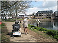
The first day of Spring around unseen Chichester (186)
Approaching a pub in Canal Wharf.
Image: © Basher Eyre
Taken: 21 Mar 2011
0.01 miles
3
The first day of Spring around unseen Chichester (187)
Railings in Canal Wharf
Image: © Basher Eyre
Taken: 21 Mar 2011
0.02 miles
6
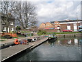
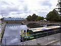
Egremont moored within Chichester Canal basin
Image: © Basher Eyre
Taken: 10 Apr 2008
0.03 miles
7
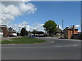
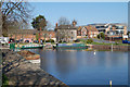
Basin Road Chichester
North away from Chichester Basin.
Image: © Dave Spicer
Taken: 16 May 2013
0.03 miles
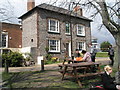
10
Chichester Canal Basin
Canal basin at the end of the Chichester branch of the Chichester Ship Canal.
Image: © Chris Richardson
Taken: 1 Apr 2009
0.03 miles