IMAGES TAKEN NEAR TO
Blomfield Drive, CHICHESTER, PO19 6BZ
Introduction
This page details the photographs taken nearby to Blomfield Drive, PO19 6BZ by members of the Geograph project.
The Geograph project started in 2005 with the aim of publishing, organising and preserving representative images for every square kilometre of Great Britain, Ireland and the Isle of Man.

There are currently over 7.5m images from over14,400 individuals and you can help contribute to the project by visiting https://www.geograph.org.uk
Image Map
Images are licensed for reuse under creativecommons.org/licenses/by-sa/2.0
Notes
- Clicking on the map will re-center to the selected point.
- The higher the marker number, the further away the image location is from the centre of the postcode.
Image Listing (4 Images Found)
Images are licensed for reuse under creativecommons.org/licenses/by-sa/2.0
Image
Details
Distance
1
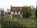
The farmhouse at Greylingwell.
The farmhouse in the grounds of Greylingwell Hospital was once the home of Anna Sewell, author of Black Beauty. The whole site is shortly to be redeveloped.
Image: © Pat Chambers
Taken: 15 Mar 2008
0.16 miles
2
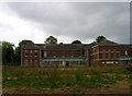
Gordon House, Chichester
Formerly part of the Graylingwell Hospital complex now awaiting another fate. The building itself is reached by a series of new roads that have been recently built and are not currently marked on the map.
Image: © Simon Carey
Taken: 24 Aug 2006
0.17 miles
4
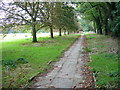
Paved path by playing field
Used by the West Sussex Literary Trail, this path is parallel to Summersdale Road.
Image: © Shazz
Taken: 16 Sep 2008
0.25 miles