IMAGES TAKEN NEAR TO
Hylters Lane, CHICHESTER, PO18 9HS
Introduction
This page details the photographs taken nearby to Hylters Lane, PO18 9HS by members of the Geograph project.
The Geograph project started in 2005 with the aim of publishing, organising and preserving representative images for every square kilometre of Great Britain, Ireland and the Isle of Man.

There are currently over 7.5m images from over14,400 individuals and you can help contribute to the project by visiting https://www.geograph.org.uk
Image Map
Images are licensed for reuse under creativecommons.org/licenses/by-sa/2.0
Notes
- Clicking on the map will re-center to the selected point.
- The higher the marker number, the further away the image location is from the centre of the postcode.
Image Listing (7 Images Found)
Images are licensed for reuse under creativecommons.org/licenses/by-sa/2.0
Image
Details
Distance
2
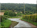
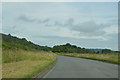
Puddle on Hylter's Lane
Just before its junction with the B2141. Across the road is the start of a bridleway which is one of the ways to access Kingley Vale National Nature Reserve.
Image: © Robin Webster
Taken: 16 Aug 2012
0.08 miles
3
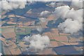
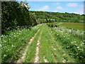
Chichester District : West Sussex Scenery
An aerial view of West Sussex with the photo location in the bottom left hand side building.
Image: © Lewis Clarke
Taken: 23 Aug 2012
0.08 miles
4
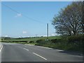
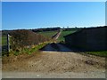
The end of Hylter's Lane
This is a cross-roads on the B2141; however the left turn is only a track, that leads up the western slope of the valley - the right turn leads to Hylters Image
Image: © David Smith
Taken: 30 Apr 2014
0.08 miles