IMAGES TAKEN NEAR TO
Creech Walk, FAREHAM, PO17 6HJ
Introduction
This page details the photographs taken nearby to Creech Walk, PO17 6HJ by members of the Geograph project.
The Geograph project started in 2005 with the aim of publishing, organising and preserving representative images for every square kilometre of Great Britain, Ireland and the Isle of Man.

There are currently over 7.5m images from over14,400 individuals and you can help contribute to the project by visiting https://www.geograph.org.uk
Image Map
Images are licensed for reuse under creativecommons.org/licenses/by-sa/2.0
Notes
- Clicking on the map will re-center to the selected point.
- The higher the marker number, the further away the image location is from the centre of the postcode.
Image Listing (7 Images Found)
Images are licensed for reuse under creativecommons.org/licenses/by-sa/2.0
Image
Details
Distance
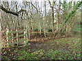
1
Gate into Wynn's Copse
Off Southwick Road.
Image: © Robin Webster
Taken: 17 Nov 2019
0.06 miles
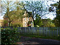
2
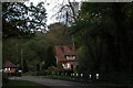
Cottages on the edge of Place Wood.
Image: © Martyn Pattison
Taken: 12 Nov 2006
0.06 miles
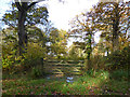
3
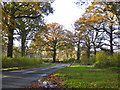
Southwick Road
Heading south between the small Wynn's Copse on the right and the very much larger Place Wood on the left.
Image: © Robin Webster
Taken: 17 Nov 2019
0.11 miles
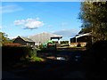
4
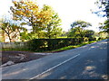
The road passing Creech Farm
I can find no name for the road.
Image: © Shazz
Taken: 25 Oct 2014
0.15 miles