IMAGES TAKEN NEAR TO
Mayles Lane, FAREHAM, PO17 5LY
Introduction
This page details the photographs taken nearby to Mayles Lane, PO17 5LY by members of the Geograph project.
The Geograph project started in 2005 with the aim of publishing, organising and preserving representative images for every square kilometre of Great Britain, Ireland and the Isle of Man.

There are currently over 7.5m images from over14,400 individuals and you can help contribute to the project by visiting https://www.geograph.org.uk
Image Map
Images are licensed for reuse under creativecommons.org/licenses/by-sa/2.0
Notes
- Clicking on the map will re-center to the selected point.
- The higher the marker number, the further away the image location is from the centre of the postcode.
Image Listing (33 Images Found)
Images are licensed for reuse under creativecommons.org/licenses/by-sa/2.0
Image
Details
Distance
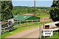
1
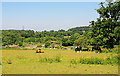
Field NE of Mayles Corner, Knowle
Looking towards Knowle Farm and the sewage works from Mayles Lane. The lefthand horse was just having a good roll.
Image: © Peter Facey
Taken: 5 Jun 2007
0.03 miles
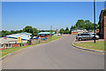
2
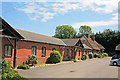
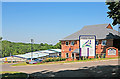
North Park Business Centre, Knowle
There is another line of offices like this off picture right. I believe the house at the end is Knowle Farmhouse.
Image: © Peter Facey
Taken: 5 Jun 2007
0.04 miles
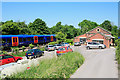
3
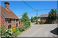
Entrance to North Park Business Centre, Knowle
The entrance is to the left of the electricity pole and then right for the Business Centre or left for Knowle Farm. Foreground left: number 4 Farm Cottages.
Image: © Peter Facey
Taken: 5 Jun 2007
0.06 miles
4
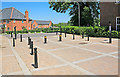
Automatic bollards separating Knowle Avenue from Mayles Lane
Knowle Village is a redevelopment as a residential area of the former Hampshire County Lunatic Asylum. It has its own dedicated access road from the A32, but has otherwise been designed to be cut off from the surrounding lanes. This automatic barrier enables the bus to enter Knowle from Mayles Lane but prevents any other vehicles from doing so.
The housing in background is Mayles Corner.
Image: © Peter Facey
Taken: 5 Jun 2007
0.06 miles
5
Entrance to Knowle Farm
With Knowle sewage works in background.
Image: © Peter Facey
Taken: 5 Jun 2007
0.07 miles
7
Business Unit next to railway line at Knowle
I'm not sure if this building may originally have been associated with the Fareham to Botley railway line, but it is now an office. I am grateful for the following information from Nigel Wassell in 2022. "This complex of buildings is marked on the 1909 edition 1:2,500 series plan (Hampshire and Isle of Wight LXVI.16, copy at https://maps.nls.uk/view/105987484) as a Gas Works. The building with the round porthole-type opening was presumably the Retort House. There was a siding into the site (presumably for coal deliveries). The building and siding is still shown on the 1946 edition of the map, but its function is not named. Just south of the headshunt for the siding was the site of Knowle Halt (opemed 1907 to serve the adjacent hospital, closed 1964). This was apparently serviced by a set of steps descending from the access road to the gasworks, which of course itself depends from Mayles Lane, but the site of the Halt (which had a concrete platform) does not seem to be visible from any publicly accessible place."
Image: © Peter Facey
Taken: 5 Jun 2007
0.09 miles
8
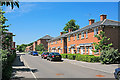
The northern part of Knowle Avenue, Knowle
Right foreground: number 222 to 231. Middle distance: the light blue car is opposite North Square.
Image: © Peter Facey
Taken: 5 Jun 2007
0.09 miles
9
Entrance to Knowle Village Business Park
Image: © Peter Facey
Taken: 5 Jun 2007
0.09 miles
10
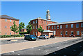
Looking across West Mews to the clock tower of North Square, Knowle
Image: © Peter Facey
Taken: 5 Jun 2007
0.10 miles