IMAGES TAKEN NEAR TO
The Spinney, FAREHAM, PO16 8QB
Introduction
This page details the photographs taken nearby to The Spinney, PO16 8QB by members of the Geograph project.
The Geograph project started in 2005 with the aim of publishing, organising and preserving representative images for every square kilometre of Great Britain, Ireland and the Isle of Man.

There are currently over 7.5m images from over14,400 individuals and you can help contribute to the project by visiting https://www.geograph.org.uk
Image Map
Images are licensed for reuse under creativecommons.org/licenses/by-sa/2.0
Notes
- Clicking on the map will re-center to the selected point.
- The higher the marker number, the further away the image location is from the centre of the postcode.
Image Listing (20 Images Found)
Images are licensed for reuse under creativecommons.org/licenses/by-sa/2.0
Image
Details
Distance
1
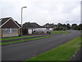
The Thicket
1950s bungalows in Wallington.
Image: © Burgess Von Thunen
Taken: 2 Aug 2012
0.09 miles
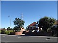
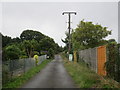
2
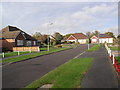
The Spinney
1950s bungalows in Wallington.
Image: © Burgess Von Thunen
Taken: 9 Nov 2011
0.11 miles
3
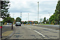
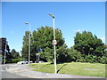
Roundabout on A27 Portchester Road
Mainly for a housing estate on the left.
Image: © Robin Webster
Taken: 16 Sep 2018
0.12 miles
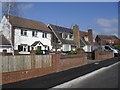
4
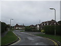
The Thicket
Looking towards The Spinney (on the left) and The Pines (on the right)
Image: © Jonathan Thacker
Taken: 1 Sep 2014
0.13 miles
5
Condor Avenue at the junction of Portchester Road
Image: © David Howard
Taken: 3 Jul 2016
0.13 miles
7
Cams Bay Close
Downend in Fareham.
Image: © Burgess Von Thunen
Taken: 21 Mar 2012
0.15 miles
10
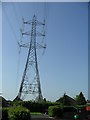
Hawkwell
Electric power line pylon in Downend.
Image: © Burgess Von Thunen
Taken: 22 May 2012
0.17 miles