IMAGES TAKEN NEAR TO
Carlton Road, FAREHAM, PO16 8JJ
Introduction
This page details the photographs taken nearby to Carlton Road, PO16 8JJ by members of the Geograph project.
The Geograph project started in 2005 with the aim of publishing, organising and preserving representative images for every square kilometre of Great Britain, Ireland and the Isle of Man.

There are currently over 7.5m images from over14,400 individuals and you can help contribute to the project by visiting https://www.geograph.org.uk
Image Map
Images are licensed for reuse under creativecommons.org/licenses/by-sa/2.0
Notes
- Clicking on the map will re-center to the selected point.
- The higher the marker number, the further away the image location is from the centre of the postcode.
Image Listing (101 Images Found)
Images are licensed for reuse under creativecommons.org/licenses/by-sa/2.0
Image
Details
Distance
1
Looking from Southwick Avenue towards the postbox in Carlton Road
Image: © Basher Eyre
Taken: 20 Dec 2008
0.04 miles
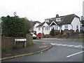
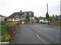
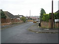
2
Junction of Southwick Avenue and Carlton Road
Image: © Basher Eyre
Taken: 20 Dec 2008
0.04 miles
3
Looking up Southwick Avenue towards Portsdown Hill
Image: © Basher Eyre
Taken: 20 Dec 2008
0.05 miles
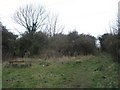
4
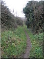
Path running parallel between the M27 and Anson Grove
Image: © Basher Eyre
Taken: 20 Dec 2008
0.06 miles
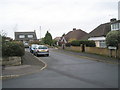
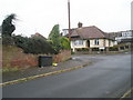
5
Junction of Portobello Grove and Southwick Avenue
Image: © Basher Eyre
Taken: 20 Dec 2008
0.06 miles
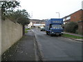
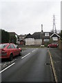
8
Looking from Portobello Grove down Southwick Avenue
Image: © Basher Eyre
Taken: 20 Dec 2008
0.07 miles
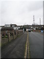
9
View from Southwick Avenue looking towards Portobello Grove
Image: © Basher Eyre
Taken: 20 Dec 2008
0.08 miles