IMAGES TAKEN NEAR TO
Holly Grove, FAREHAM, PO16 7UP
Introduction
This page details the photographs taken nearby to Holly Grove, PO16 7UP by members of the Geograph project.
The Geograph project started in 2005 with the aim of publishing, organising and preserving representative images for every square kilometre of Great Britain, Ireland and the Isle of Man.

There are currently over 7.5m images from over14,400 individuals and you can help contribute to the project by visiting https://www.geograph.org.uk
Image Map
Images are licensed for reuse under creativecommons.org/licenses/by-sa/2.0
Notes
- Clicking on the map will re-center to the selected point.
- The higher the marker number, the further away the image location is from the centre of the postcode.
Image Listing (27 Images Found)
Images are licensed for reuse under creativecommons.org/licenses/by-sa/2.0
Image
Details
Distance
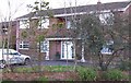
1
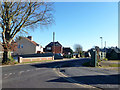
Houses on Kiln Road
Looking from the junction with Holly Grove.
Image: © Robin Webster
Taken: 6 Dec 2014
0.06 miles
2
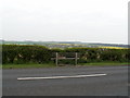
Kiln Road Seat
The famous Kiln Rd seat with views to the north across the M27 and open countryside, at least there is providing you're 6ft otherwise you get to look at a hedge.
Image: © Trevor Carpenter
Taken: 28 Apr 2006
0.08 miles
4
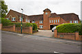
Funtley Court
Seen across Funtley Hill. Funtley Court is business accommodation made from an old Victorian school. This is one part of it. There is another building slightly lower down the hill.
Image: © Peter Facey
Taken: 4 May 2009
0.13 miles
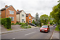
5
House with a story-Fareham
This house was built in the 60's on a heavily wooded site at the corner of Kiln Rd. and Maylings Farm Rd. It started to experience severe subsidence soon after. It had to be demolished and rebuilt a few feet from its original position.
Image: © Colin Babb
Taken: 23 Mar 2008
0.14 miles
6
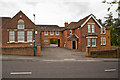
Funtley Court
Seen across Funtley Hill. Funtley Court is business accommodation made from an old Victorian school. An inscription on the yellow stonework in the gable at left reads "Board school 1880". The internet is silent on the history of this school. See also Image According to http://www.channel4.com/history/microsites/H/history/guide19/timeline57.html the Elementary Education Act 1870 introduced state schools, known as "board schools" because they were run by locally elected boards. They were funded by a combination of local rates and government money and charged a small fee per pupil.
Image: © Peter Facey
Taken: 4 May 2009
0.15 miles
7
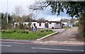
Scout Hut-Fareham
Scout hut in Highlands Rd, a railway tunnel runs right below here.
Image: © Colin Babb
Taken: 23 Mar 2008
0.17 miles
8
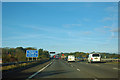
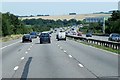
M27 - no hard shoulder for 150 yards
The restriction is on the bridge over a road called Funtley Hill. The circumstances seem to suggest that the bridge was built wide enough originally, but there was insufficient width for the addition of a large lead-in crash barrier when the matrix warning sign was installed just the other side of the bridge.
Image: © Robin Webster
Taken: 30 Oct 2012
0.18 miles
10
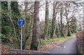
Path from Highlands Rd to Miller Drive-Fareham
A short path that reduces a long walk between Miller Dr and Highlands Rd.
Image: © Colin Babb
Taken: 23 Mar 2008
0.19 miles