IMAGES TAKEN NEAR TO
Laburnum Road, FAREHAM, PO16 0SL
Introduction
This page details the photographs taken nearby to Laburnum Road, PO16 0SL by members of the Geograph project.
The Geograph project started in 2005 with the aim of publishing, organising and preserving representative images for every square kilometre of Great Britain, Ireland and the Isle of Man.

There are currently over 7.5m images from over14,400 individuals and you can help contribute to the project by visiting https://www.geograph.org.uk
Image Map
Images are licensed for reuse under creativecommons.org/licenses/by-sa/2.0
Notes
- Clicking on the map will re-center to the selected point.
- The higher the marker number, the further away the image location is from the centre of the postcode.
Image Listing (37 Images Found)
Images are licensed for reuse under creativecommons.org/licenses/by-sa/2.0
Image
Details
Distance
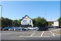
1
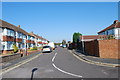
Junction of Watersmeet and The Moorings - Fareham
Looking south along Watersmeet at its junction with The Moorings. Quite a pleasant estate, situated within a very short walk of Fareham town centre.
Image: © Colin Babb
Taken: 25 Jun 2010
0.11 miles
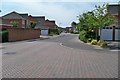
2
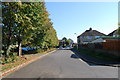
Houses on Elms Road. Fareham
Looking from Alders Road.
Image: © Robin Webster
Taken: 5 Jun 2019
0.12 miles
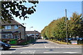
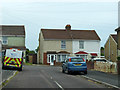
8
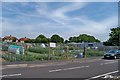
Salterns Lane Allotments -Fareham
Popular allotment area.
Image: © Colin Babb
Taken: 25 Jun 2010
0.14 miles