IMAGES TAKEN NEAR TO
Walton Court, FAREHAM, PO15 6EZ
Introduction
This page details the photographs taken nearby to Walton Court, PO15 6EZ by members of the Geograph project.
The Geograph project started in 2005 with the aim of publishing, organising and preserving representative images for every square kilometre of Great Britain, Ireland and the Isle of Man.

There are currently over 7.5m images from over14,400 individuals and you can help contribute to the project by visiting https://www.geograph.org.uk
Image Map
Images are licensed for reuse under creativecommons.org/licenses/by-sa/2.0
Notes
- Clicking on the map will re-center to the selected point.
- The higher the marker number, the further away the image location is from the centre of the postcode.
Image Listing (8 Images Found)
Images are licensed for reuse under creativecommons.org/licenses/by-sa/2.0
Image
Details
Distance
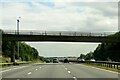
1
Footbridge north of Hill Park, Fareham
A bridge which gives access to countryside from the housing estates of Hill Park
Image: © David Smith
Taken: 26 Jun 2013
0.06 miles

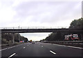
3
The M27 heading east under a footbridge
Image: © Steve Daniels
Taken: 7 Aug 2015
0.08 miles

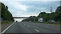
5

Borough of Fareham : M27 Motorway
The M27 Motorway between Junction 9 (Park Gate Interchange) and Junction 10 (North Hill).
Image: © Lewis Clarke
Taken: 28 Mar 2018
0.09 miles
6
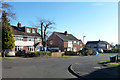
Houses on Hill Park Road
Viewed from the junction with The Greendale.
Image: © Robin Webster
Taken: 6 Dec 2014
0.20 miles
7
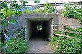
Subway under M27 in line with track of dismantled railway north of Hill Park
Beyond the subway, the footpath follows the railway.
Image: © Peter Facey
Taken: 5 Jun 2007
0.24 miles