IMAGES TAKEN NEAR TO
Sunlight Gardens, FAREHAM, PO15 6DG
Introduction
This page details the photographs taken nearby to Sunlight Gardens, PO15 6DG by members of the Geograph project.
The Geograph project started in 2005 with the aim of publishing, organising and preserving representative images for every square kilometre of Great Britain, Ireland and the Isle of Man.

There are currently over 7.5m images from over14,400 individuals and you can help contribute to the project by visiting https://www.geograph.org.uk
Image Map
Images are licensed for reuse under creativecommons.org/licenses/by-sa/2.0
Notes
- Clicking on the map will re-center to the selected point.
- The higher the marker number, the further away the image location is from the centre of the postcode.
Image Listing (38 Images Found)
Images are licensed for reuse under creativecommons.org/licenses/by-sa/2.0
Image
Details
Distance
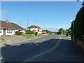
1
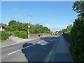
Approaching a railway bridge in Gudge Heath Lane
Image: © Basher Eyre
Taken: 21 May 2011
0.08 miles
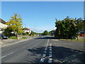
2
Path just north of the railway bridge in Gudge Heath Lane
Image: © Basher Eyre
Taken: 21 May 2011
0.08 miles
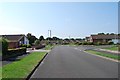
6
Junction of Gudge Heath Lane and Murray Close
Image: © Basher Eyre
Taken: 21 May 2011
0.10 miles
7
Looking from Gudge Heath Lane into Murray Close
Image: © Basher Eyre
Taken: 21 May 2011
0.10 miles
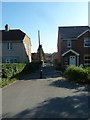
8

Looking from Gudge Heath Lane into Sunlight Gardens
Image: © Basher Eyre
Taken: 21 May 2011
0.10 miles
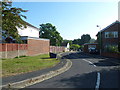
9
Looking from Gudge Heath Lane into Oak Road
Image: © Basher Eyre
Taken: 21 May 2011
0.11 miles
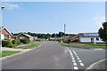
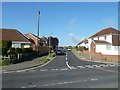
10

Junction of Gudge Heath Lane and Sunlight Gardens
Image: © Basher Eyre
Taken: 21 May 2011
0.12 miles