IMAGES TAKEN NEAR TO
Amarylis Close, FAREHAM, PO15 5LQ
Introduction
This page details the photographs taken nearby to Amarylis Close, PO15 5LQ by members of the Geograph project.
The Geograph project started in 2005 with the aim of publishing, organising and preserving representative images for every square kilometre of Great Britain, Ireland and the Isle of Man.

There are currently over 7.5m images from over14,400 individuals and you can help contribute to the project by visiting https://www.geograph.org.uk
Image Map
Images are licensed for reuse under creativecommons.org/licenses/by-sa/2.0
Notes
- Clicking on the map will re-center to the selected point.
- The higher the marker number, the further away the image location is from the centre of the postcode.
Image Listing (9 Images Found)
Images are licensed for reuse under creativecommons.org/licenses/by-sa/2.0
Image
Details
Distance
1

Civic Amenity Tip - Sedgenworth Fareham
A view of the sales area of the well run Civic Amenity Tip, near Fareham
Image: © Colin Babb
Taken: 21 Jun 2010
0.10 miles
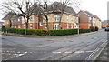
2
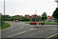
Roundabout and housing at Titchfield Park
Image: © Peter Facey
Taken: 8 Jun 2007
0.19 miles
3
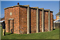
RAF Titchfield: WWII hardened sleeping shelter (1)
The sole survivor of what I believe to have been two identical former WWII hardened sleeping shelters for the personnel of RAF Titchfield No. 12 Balloon Squadron. RAF Titchfield was a so called non-flying station, and the Headquarters for anti-aircraft barrage balloon operations in the Southampton and Portsmouth areas during the Second World War.
The shelters are currently listed on the Extended Defence of Britain archive (EDoB) as civil air raid shelters 'e49885 Extant' and 'e49884 Removed'. However, their proximity to the former RAF Titchfield (now an industrial estate), suggest to me they were for the use of the military. The shelter here conforms to the standard RAF hardened sleeping shelter [https://www.geograph.org.uk/photo/4703879] although the height of this building is considerably taller (the figure gives a sense of scale) with small circular openings (now blocked) at each end. There is no longer any access to the interior, and with its southern end to a large extent unprotected, this may in fact have been an emergency exit, as the main entrance at the north has a V-shape blast deflecting wall to the full height of the shelter.
Google Earth view of site (note V-shape blast wall): https://media.geograph.org.uk/files/7eabe3a1649ffa2b3ff8c02ebfd5659f/RAF_Titchfield_Shelter1-original.jpg
RAF Titchfield - a history: https://nfhwa.org/raf-titchfield-history-barrage-balloon-command/#:~:text=RAF%20Titchfield%20near%20Fareham%2C%20Hampshire,(12%20Balloon%20Centre)%20Titchfield.
Image
Image: © Mike Searle
Taken: 2 Mar 2023
0.20 miles
4
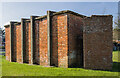
RAF Titchfield: WWII hardened sleeping shelter (2)
The V-shaped blast wall at the northern end covers the entire height of the building, which might indicate there was a mezzanine floor. A series of concrete bands surround the structure laterally along its length, giving added strength to the integrity of the building. It would have survived all but a direct hit.
Image
Image: © Mike Searle
Taken: 2 Mar 2023
0.20 miles
5
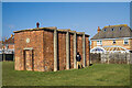
RAF Titchfield: WWII hardened sleeping shelter (3)
-
Image
Image: © Mike Searle
Taken: 2 Mar 2023
0.20 miles
6
Corner of Segensworth Road and Whiteley Lane
Image: © David Martin
Taken: 14 Feb 2020
0.21 miles
7
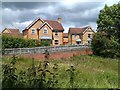
Houses and balancing pond
When these houses were constructed in the early 2000s, a short section of Segensworth Road was closed and the route retained as a footpath only. The balancing pond created as part of the development has here almost entirely disappeared under invading vegetation.
Image: © David Martin
Taken: 9 Jun 2011
0.22 miles
8
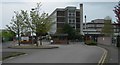
Office for National Statistics
One of the locations of the Office for National Statistics, this one is in the Titchfield Park area near to Fareham.
Image: © Jim Goldsmith
Taken: 30 Apr 2006
0.22 miles
9
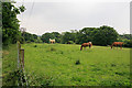
Footpath and field south of railway line at Titchfield Park
The footpath is to the left of the fence.
Image: © Peter Facey
Taken: 8 Jun 2007
0.24 miles