IMAGES TAKEN NEAR TO
Southmead Road, FAREHAM, PO15 5JY
Introduction
This page details the photographs taken nearby to Southmead Road, PO15 5JY by members of the Geograph project.
The Geograph project started in 2005 with the aim of publishing, organising and preserving representative images for every square kilometre of Great Britain, Ireland and the Isle of Man.

There are currently over 7.5m images from over14,400 individuals and you can help contribute to the project by visiting https://www.geograph.org.uk
Image Map
Images are licensed for reuse under creativecommons.org/licenses/by-sa/2.0
Notes
- Clicking on the map will re-center to the selected point.
- The higher the marker number, the further away the image location is from the centre of the postcode.
Image Listing (43 Images Found)
Images are licensed for reuse under creativecommons.org/licenses/by-sa/2.0
Image
Details
Distance
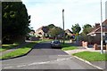
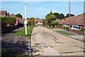
1
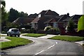
Southmead Road, Fareham
Viewed from Jonathan Road.
Image: © William Grierson
Taken: 19 Aug 2009
0.01 miles
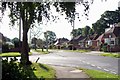
2
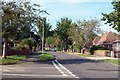
Jonathan Road, Fareham
Looking south from junction with Southmead Road.
Image: © William Grierson
Taken: 19 Aug 2009
0.02 miles
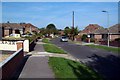
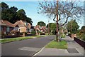
5
Jonathan Road, Fareham
Looking south from entrance to Regency Place.
Image: © William Grierson
Taken: 19 Aug 2009
0.04 miles
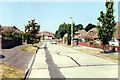
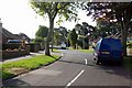
6
Southmead Road, Fareham
Southmead Road with Jonathan Road joining on left.
Image: © William Grierson
Taken: 19 Aug 2009
0.04 miles

9
Southmead Road, Fareham
Viewed from Meadowbank Road.
Image: © William Grierson
Taken: 19 Aug 2009
0.05 miles
10
Jonathan Road, Fareham
Looking west from near junction with Julie Avenue.
Image: © William Grierson
Taken: 19 Aug 2009
0.08 miles