IMAGES TAKEN NEAR TO
Rosedale Close, FAREHAM, PO14 4EL
Introduction
This page details the photographs taken nearby to Rosedale Close, PO14 4EL by members of the Geograph project.
The Geograph project started in 2005 with the aim of publishing, organising and preserving representative images for every square kilometre of Great Britain, Ireland and the Isle of Man.

There are currently over 7.5m images from over14,400 individuals and you can help contribute to the project by visiting https://www.geograph.org.uk
Image Map
Images are licensed for reuse under creativecommons.org/licenses/by-sa/2.0
Notes
- Clicking on the map will re-center to the selected point.
- The higher the marker number, the further away the image location is from the centre of the postcode.
Image Listing (263 Images Found)
Images are licensed for reuse under creativecommons.org/licenses/by-sa/2.0
Image
Details
Distance
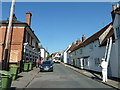
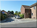
1
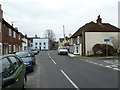
Approaching the junction of West Street and Chapel Close
Image: © Basher Eyre
Taken: 3 Apr 2013
0.03 miles
2
Looking out from Shakespeare Mews into West Street
Image: © Basher Eyre
Taken: 3 Apr 2013
0.03 miles
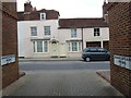
3
Looking from West Street into Chapel Close
Image: © Basher Eyre
Taken: 3 Apr 2013
0.04 miles
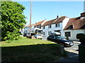
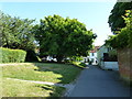
5
West Street in the early morning sunshine
Image: © Basher Eyre
Taken: 3 Jun 2011
0.05 miles
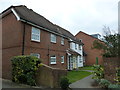
6
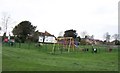
Barry's Meadow Play Area-Titchfield
No demand for the swings on this grey March afternoon.
Image: © Colin Babb
Taken: 17 Mar 2008
0.06 miles
7
Looking from the Coach Hill footpath into West Street
Image: © Basher Eyre
Taken: 3 Jun 2011
0.07 miles
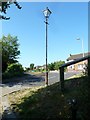
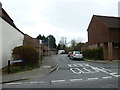
9
Looking from East Street into Chapelside
Image: © Basher Eyre
Taken: 3 Jun 2011
0.07 miles
10
Approaching West Street on the path from Coach Hill
Image: © Basher Eyre
Taken: 3 Jun 2011
0.08 miles