IMAGES TAKEN NEAR TO
Gosport Road, FAREHAM, PO14 2AB
Introduction
This page details the photographs taken nearby to Gosport Road, PO14 2AB by members of the Geograph project.
The Geograph project started in 2005 with the aim of publishing, organising and preserving representative images for every square kilometre of Great Britain, Ireland and the Isle of Man.

There are currently over 7.5m images from over14,400 individuals and you can help contribute to the project by visiting https://www.geograph.org.uk
Image Map
Images are licensed for reuse under creativecommons.org/licenses/by-sa/2.0
Notes
- Clicking on the map will re-center to the selected point.
- The higher the marker number, the further away the image location is from the centre of the postcode.
Image Listing (6 Images Found)
Images are licensed for reuse under creativecommons.org/licenses/by-sa/2.0
Image
Details
Distance
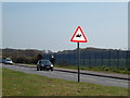
1
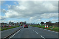
B3334 Gosport Road, Peel Common
Westwards towards Stubbington.
Image: © Robin Webster
Taken: 1 Mar 2020
0.09 miles
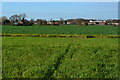
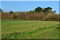
3
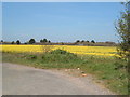
Field of oilseed rape
Oilseed rape in bloom at Peel Common
Image: © Margaret Sutton
Taken: 5 Apr 2007
0.14 miles
6
Gosport Road
At the back of HMS Daedalus, looking east towards the junction with Newgate Lane
Image: © Margaret Sutton
Taken: 5 Apr 2007
0.24 miles