IMAGES TAKEN NEAR TO
Ramsey Avenue, GOSPORT, PO13 8NW
Introduction
This page details the photographs taken nearby to Ramsey Avenue, PO13 8NW by members of the Geograph project.
The Geograph project started in 2005 with the aim of publishing, organising and preserving representative images for every square kilometre of Great Britain, Ireland and the Isle of Man.

There are currently over 7.5m images from over14,400 individuals and you can help contribute to the project by visiting https://www.geograph.org.uk
Image Map
Images are licensed for reuse under creativecommons.org/licenses/by-sa/2.0
Notes
- Clicking on the map will re-center to the selected point.
- The higher the marker number, the further away the image location is from the centre of the postcode.
Image Listing (98 Images Found)
Images are licensed for reuse under creativecommons.org/licenses/by-sa/2.0
Image
Details
Distance
1
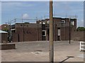
Pubs of Gosport - Spread Eagle (2007)
Situated in Nimrod Drive, this pub is now called The Grange.
Image: © Barry Shimmon
Taken: 25 May 2007
0.02 miles
2
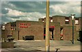
Pubs of Gosport - Spread Eagle (1987)
Situated in Nimrod Drive.
Image: © Barry Shimmon
Taken: 21 Mar 1987
0.02 miles