IMAGES TAKEN NEAR TO
Priory Road, GOSPORT, PO12 4LF
Introduction
This page details the photographs taken nearby to Priory Road, PO12 4LF by members of the Geograph project.
The Geograph project started in 2005 with the aim of publishing, organising and preserving representative images for every square kilometre of Great Britain, Ireland and the Isle of Man.

There are currently over 7.5m images from over14,400 individuals and you can help contribute to the project by visiting https://www.geograph.org.uk
Image Map
Images are licensed for reuse under creativecommons.org/licenses/by-sa/2.0
Notes
- Clicking on the map will re-center to the selected point.
- The higher the marker number, the further away the image location is from the centre of the postcode.
Image Listing (201 Images Found)
Images are licensed for reuse under creativecommons.org/licenses/by-sa/2.0
Image
Details
Distance
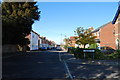
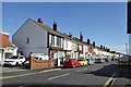
1
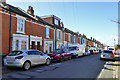
Row on Priory Road, Hardway
About 36 houses in a terrace, they appeared on maps round about 1900.
Image: © Robin Webster
Taken: 1 Mar 2020
0.02 miles
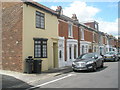
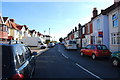
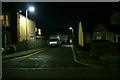
3
Looking from Priory Road into Castle View
Image: © Basher Eyre
Taken: 21 Jun 2009
0.03 miles
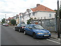
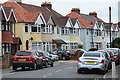
10
Row on St Thomas's Road, Hardway
It appeared on maps round about 1900.
Image: © Robin Webster
Taken: 1 Mar 2020
0.07 miles