IMAGES TAKEN NEAR TO
Reeds Place, GOSPORT, PO12 3HR
Introduction
This page details the photographs taken nearby to Reeds Place, PO12 3HR by members of the Geograph project.
The Geograph project started in 2005 with the aim of publishing, organising and preserving representative images for every square kilometre of Great Britain, Ireland and the Isle of Man.

There are currently over 7.5m images from over14,400 individuals and you can help contribute to the project by visiting https://www.geograph.org.uk
Image Map
Images are licensed for reuse under creativecommons.org/licenses/by-sa/2.0
Notes
- Clicking on the map will re-center to the selected point.
- The higher the marker number, the further away the image location is from the centre of the postcode.
Image Listing (352 Images Found)
Images are licensed for reuse under creativecommons.org/licenses/by-sa/2.0
Image
Details
Distance
2
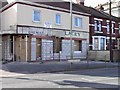
The old Chemist being converted to flats on the corner of Anns Hill Road
Possibly not the most attractive pic, but this was an old chemist shop from the early seventies as it was again transformed. The signs underneath were only visible for a couple of days.
Image: © Dysdera
Taken: 4 Feb 2003
0.01 miles
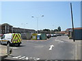
6

Junction of Forton Road and Whites Place
Image: © Basher Eyre
Taken: 29 May 2009
0.03 miles
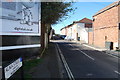
7
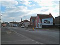
Forton Road, Gosport
The A32 near the Crossways junction.
Image: © Margaret Sutton
Taken: 6 Mar 2005
0.03 miles
8
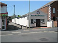
Gosport Spiritualist Church in Forton Road
Image: © Basher Eyre
Taken: 29 May 2009
0.03 miles