IMAGES TAKEN NEAR TO
Haslar Road, GOSPORT, PO12 2AU
Introduction
This page details the photographs taken nearby to Haslar Road, PO12 2AU by members of the Geograph project.
The Geograph project started in 2005 with the aim of publishing, organising and preserving representative images for every square kilometre of Great Britain, Ireland and the Isle of Man.

There are currently over 7.5m images from over14,400 individuals and you can help contribute to the project by visiting https://www.geograph.org.uk
Image Map
Images are licensed for reuse under creativecommons.org/licenses/by-sa/2.0
Notes
- Clicking on the map will re-center to the selected point.
- The higher the marker number, the further away the image location is from the centre of the postcode.
Image Listing (152 Images Found)
Images are licensed for reuse under creativecommons.org/licenses/by-sa/2.0
Image
Details
Distance
1

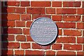
Wall and chimney, Gunboat Yard
Wall is Grade II* listed. https://historicengland.org.uk/listing/the-list/list-entry/1431191
Image: © N Chadwick
Taken: 1 Dec 2018
0.05 miles
2

Gunboat Yard Boundary Wall and Watchtower
Grade II* listed. https://historicengland.org.uk/listing/the-list/list-entry/1431191
Image: © N Chadwick
Taken: 1 Dec 2018
0.06 miles
3

Haslar Maritime Technology Park
Qinetiq will now rent you lab space in to old Defence Research Agency at Haslar Docks see the Image
Image: © Glyn Baker
Taken: 5 Oct 2018
0.06 miles
4

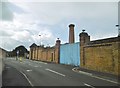
Old wall, Haslar Road
Inside the site has been redeveloped as a high security marine technology park, operated by QinetiQ.
Image: © Robin Webster
Taken: 15 Dec 2014
0.07 miles

6
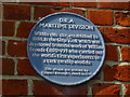
D.R.A Plaque
The Defence Research Agency came into being in 1991 it was merged with other MOD quangos in 1995 and was then essentially Privatised in 2001.
Image: © Glyn Baker
Taken: 5 Oct 2018
0.07 miles
7
Gosport, disused chimney
At the southern end of Haslar Road. The chimney appears once to have served Naval experimental tanks; the site appears to be for sale.
Image: © Mike Faherty
Taken: 9 Sep 2017
0.07 miles
8
The Solent Way (258)
More information is at http://www.engineering-timelines.com/scripts/engineeringItem.asp?id=443.
Image: © Shazz
Taken: 11 Sep 2012
0.07 miles
9

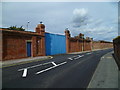
Haslar Rd and Gunboat Yard Boundary Wall
The wall and watch tower are Grade II* listed. https://historicengland.org.uk/listing/the-list/list-entry/1431191
Image: © N Chadwick
Taken: 1 Dec 2018
0.07 miles
10
The Solent Way (257)
The Way goes along Haslar Way. A close up of the blue plaque is at Image
Image: © Shazz
Taken: 11 Sep 2012
0.08 miles