IMAGES TAKEN NEAR TO
Havant Road, HAYLING ISLAND, PO11 0PX
Introduction
This page details the photographs taken nearby to Havant Road, PO11 0PX by members of the Geograph project.
The Geograph project started in 2005 with the aim of publishing, organising and preserving representative images for every square kilometre of Great Britain, Ireland and the Isle of Man.

There are currently over 7.5m images from over14,400 individuals and you can help contribute to the project by visiting https://www.geograph.org.uk
Image Map
Images are licensed for reuse under creativecommons.org/licenses/by-sa/2.0
Notes
- Clicking on the map will re-center to the selected point.
- The higher the marker number, the further away the image location is from the centre of the postcode.
Image Listing (98 Images Found)
Images are licensed for reuse under creativecommons.org/licenses/by-sa/2.0
Image
Details
Distance
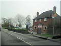

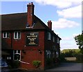
6
Maypole PH on Hayling Island seen from footpath
Image: © Shazz
Taken: 2 Oct 2009
0.09 miles
7
2016: a year on Geograph (Day 257)
Now that is a sign to tempt the eyes!
(The Maypole, Havant Road, Hayling Island)
Image: © Basher Eyre
Taken: 13 Sep 2016
0.10 miles
10
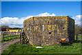
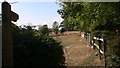
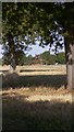
WWII Hampshire: Hayling Island - Mill Rithe pillbox (18)
-
Pillbox (unclassified): DoB ID: S0012784
Closer view showing the small embrasures and the protruding brickwork at the corners.
Image
Image: © Mike Searle
Taken: 21 Mar 2017
0.11 miles