IMAGES TAKEN NEAR TO
St. Georges Road, HAYLING ISLAND, PO11 0BS
Introduction
This page details the photographs taken nearby to St. Georges Road, PO11 0BS by members of the Geograph project.
The Geograph project started in 2005 with the aim of publishing, organising and preserving representative images for every square kilometre of Great Britain, Ireland and the Isle of Man.

There are currently over 7.5m images from over14,400 individuals and you can help contribute to the project by visiting https://www.geograph.org.uk
Image Map
Images are licensed for reuse under creativecommons.org/licenses/by-sa/2.0
Notes
- Clicking on the map will re-center to the selected point.
- The higher the marker number, the further away the image location is from the centre of the postcode.
Image Listing (92 Images Found)
Images are licensed for reuse under creativecommons.org/licenses/by-sa/2.0
Image
Details
Distance
1
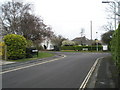
Junction of St Helen's and St George's Road
Image: © Basher Eyre
Taken: 29 Mar 2008
0.04 miles
2
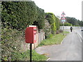
Postbox just before junction of Seafront and St George's Road
Seafront is used here as a proper noun- it is the name of the road.
Image: © Basher Eyre
Taken: 29 Mar 2008
0.05 miles
3
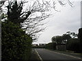
Looking southwards down St George's Road towards the seafront
Image: © Basher Eyre
Taken: 29 Mar 2008
0.06 miles
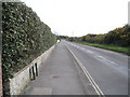
5
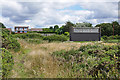
Pumping station, South Hayling
What appears to be a water pumping station in the scrubland near the Sinah Common golf course. The houses in the background are on the Sea Front
Image: © Alan Hunt
Taken: 14 Jul 2016
0.08 miles
6
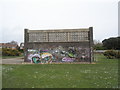
Mysterious graffiti covered building near the seafront
I could not ascertain what it was.
Image: © Basher Eyre
Taken: 29 Mar 2008
0.09 miles
7
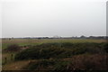
Hayling golf course.
This links course (they reckon one of the best in the South of England) is set in 190 acres of Sinah Common, which is designated a Site of Special Scientific Interest. The course is bordered by the beach to the south and West, and the road to the North, and Sinah lake to the East. This view is taken looking SouthWest(ish) with Sinah lake in the far distance.
Image: © Martyn Pattison
Taken: 14 Jan 2006
0.10 miles
9
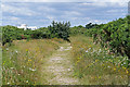
Hayling Island scrubland
A path across the scrubland of Sinah Common. These areas of scrub are designated as local wildlife reserves. The art deco golf club house can be seen in the background.
Image: © Alan Hunt
Taken: 14 Jul 2016
0.12 miles
10
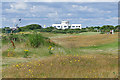
Sinah Common golf course
The public golf course at Sinah Common on Hayling Island. The art deco clubhouse can be seen in the background.
Image: © Alan Hunt
Taken: 14 Jul 2016
0.13 miles