IMAGES TAKEN NEAR TO
Woodmancote Lane, EMSWORTH, PO10 8RB
Introduction
This page details the photographs taken nearby to Woodmancote Lane, PO10 8RB by members of the Geograph project.
The Geograph project started in 2005 with the aim of publishing, organising and preserving representative images for every square kilometre of Great Britain, Ireland and the Isle of Man.

There are currently over 7.5m images from over14,400 individuals and you can help contribute to the project by visiting https://www.geograph.org.uk
Image Map
Images are licensed for reuse under creativecommons.org/licenses/by-sa/2.0
Notes
- Clicking on the map will re-center to the selected point.
- The higher the marker number, the further away the image location is from the centre of the postcode.
Image Listing (8 Images Found)
Images are licensed for reuse under creativecommons.org/licenses/by-sa/2.0
Image
Details
Distance
1
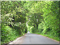
Marlpit Lane
The name presumably refers to Hambrook Marl Pit, a large worked-out pit (mapped as 'gravel pit') behind the hedge to the right.
Image: © Robin Webster
Taken: 23 May 2014
0.15 miles
5
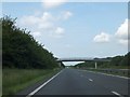
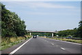
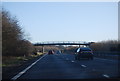
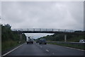
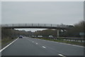
Footbridge over A27
The footbridge carries a path which was rerouted as a result of the construction of the dual carriageway. Formerly the path crossed the line of the A27 about 250 metres to the west of this bridge
Image: © David Smith
Taken: 25 Jun 2013
0.22 miles
7
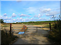
Gravel Pit near Woodmancote
May well be used as an amenity tip now as plenty of rubbish had been dumped in the entrance.
Image: © Simon Carey
Taken: 28 Aug 2006
0.22 miles