IMAGES TAKEN NEAR TO
Dunkirk Rise, EMSWORTH, PO10 8QE
Introduction
This page details the photographs taken nearby to Dunkirk Rise, PO10 8QE by members of the Geograph project.
The Geograph project started in 2005 with the aim of publishing, organising and preserving representative images for every square kilometre of Great Britain, Ireland and the Isle of Man.

There are currently over 7.5m images from over14,400 individuals and you can help contribute to the project by visiting https://www.geograph.org.uk
Image Map
Images are licensed for reuse under creativecommons.org/licenses/by-sa/2.0
Notes
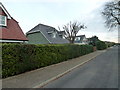
- Clicking on the map will re-center to the selected point.
- The higher the marker number, the further away the image location is from the centre of the postcode.
Image Listing (53 Images Found)
Images are licensed for reuse under creativecommons.org/licenses/by-sa/2.0
Image
Details
Distance
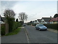
1
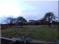
Field, Southbourne
From Breach Avenue.
Image: © Hamish Griffin
Taken: 29 Jan 2015
0.11 miles
2
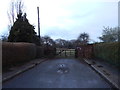
The end of Breach Avenue
Looking into a field.
Image: © Hamish Griffin
Taken: 29 Jan 2015
0.12 miles
3
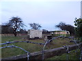
Old Caravans, Southbourne
From the end of Breach Avenue.
Image: © Hamish Griffin
Taken: 29 Jan 2015
0.12 miles
7
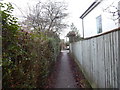
Path, Southbourne
This is the Breach Avenue/Stein Road path I think. Unfortunately I doesn't look the same on Google Street View. If I am correct this is Breach Avenue ahead.
Image: © Hamish Griffin
Taken: 29 Jan 2015
0.15 miles
9
Breach Avenue
In the Breach suburb of Southbourne.
Image: © Hamish Griffin
Taken: 23 Jun 2019
0.16 miles
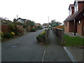
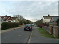
10
Looking from South Lane into Stein Road
Image: © Basher Eyre
Taken: 27 Nov 2010
0.16 miles