IMAGES TAKEN NEAR TO
Longlands Road, EMSWORTH, PO10 8HL
Introduction
This page details the photographs taken nearby to Longlands Road, PO10 8HL by members of the Geograph project.
The Geograph project started in 2005 with the aim of publishing, organising and preserving representative images for every square kilometre of Great Britain, Ireland and the Isle of Man.

There are currently over 7.5m images from over14,400 individuals and you can help contribute to the project by visiting https://www.geograph.org.uk
Image Map
Images are licensed for reuse under creativecommons.org/licenses/by-sa/2.0
Notes
- Clicking on the map will re-center to the selected point.
- The higher the marker number, the further away the image location is from the centre of the postcode.
Image Listing (169 Images Found)
Images are licensed for reuse under creativecommons.org/licenses/by-sa/2.0
Image
Details
Distance
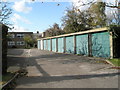
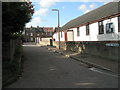
2
Access from the garages in Second Avenue
Image: © Basher Eyre
Taken: 28 Oct 2008
0.01 miles
5
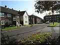
Looking towards the flats in Second Avenue
Image: © Basher Eyre
Taken: 28 Oct 2008
0.04 miles
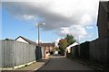
6
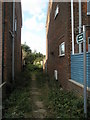
Somewhat inaccessible footpath between Second Avenue and Garsons Road
Image: © Basher Eyre
Taken: 28 Oct 2008
0.06 miles
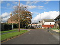
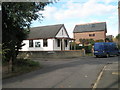
7
Second Avenue by Southbourne Free Church
Image: © Basher Eyre
Taken: 28 Oct 2008
0.07 miles
9
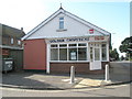
The Golden Chopsticks on the A259 at Southbourne
Image: © Basher Eyre
Taken: 28 Oct 2008
0.07 miles
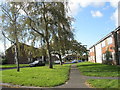
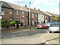
10
Junction of The Drive with Second Avenue
Image: © Basher Eyre
Taken: 28 Oct 2008
0.07 miles