IMAGES TAKEN NEAR TO
Kitter Drive, PLYMOUTH, PL9 9UJ
Introduction
This page details the photographs taken nearby to Kitter Drive, PL9 9UJ by members of the Geograph project.
The Geograph project started in 2005 with the aim of publishing, organising and preserving representative images for every square kilometre of Great Britain, Ireland and the Isle of Man.

There are currently over 7.5m images from over14,400 individuals and you can help contribute to the project by visiting https://www.geograph.org.uk
Image Map
Images are licensed for reuse under creativecommons.org/licenses/by-sa/2.0
Notes
- Clicking on the map will re-center to the selected point.
- The higher the marker number, the further away the image location is from the centre of the postcode.
Image Listing (8 Images Found)
Images are licensed for reuse under creativecommons.org/licenses/by-sa/2.0
Image
Details
Distance
1
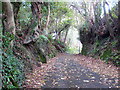
Pedestrianised lane behind Goswela Gardens
Was originally a vehicular route but now barred by bollards.
Image: © Rod Allday
Taken: 24 Oct 2009
0.09 miles
2
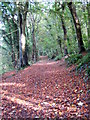
Footpath in Jew's Wood
Lined by mature beech trees and with a colourful carpet of Autumn leaves.
Image: © Rod Allday
Taken: 24 Oct 2009
0.12 miles
3
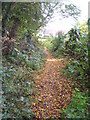
Footpath on the edge of Jew's Wood Plymstock
Image: © Rod Allday
Taken: 24 Oct 2009
0.13 miles
4
Carrollsland housing development
New housing going up on the edge of Plymouth. Interesting to note that the planned designs are for 2, 3, and 4-bed properties; also this patch of green belt is outwith the Plymouth City Council boundary.
Image: © Jonathan Billinger
Taken: 28 Nov 2007
0.15 miles
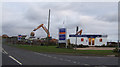
5
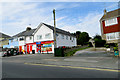
Goosewell Road
Houses and shops near Spriddlestone.
Image: © Robert Ashby
Taken: 4 Aug 2015
0.19 miles
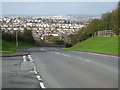
6
Looking Down to the Valley Bottom Along Goosewell Road
Image: © Tony Atkin
Taken: 26 Jul 2008
0.19 miles
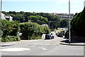
7
Goosewell Road
Looking across Plymstock.
Image: © Rod Allday
Taken: 24 Oct 2009
0.21 miles
8

Coombe Dean School
Viewed from the footpath in Jew's Wood.
Image: © Rod Allday
Taken: 24 Oct 2009
0.22 miles