IMAGES TAKEN NEAR TO
PL9 9QX
Introduction
This page details the photographs taken nearby to PL9 9QX by members of the Geograph project.
The Geograph project started in 2005 with the aim of publishing, organising and preserving representative images for every square kilometre of Great Britain, Ireland and the Isle of Man.

There are currently over 7.5m images from over14,400 individuals and you can help contribute to the project by visiting https://www.geograph.org.uk
Image Map
Images are licensed for reuse under creativecommons.org/licenses/by-sa/2.0
Notes
- Clicking on the map will re-center to the selected point.
- The higher the marker number, the further away the image location is from the centre of the postcode.
Image Listing (6 Images Found)
Images are licensed for reuse under creativecommons.org/licenses/by-sa/2.0
Image
Details
Distance
1
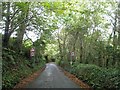
Part of Barn Farm
The minor road is the start of Hooe Hill which goes down to Hooe.
Image: © jeff collins
Taken: 26 Mar 2014
0.03 miles
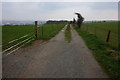
2
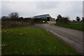
Private Farm Track ahead.
The track ahead goes to Barn Farm and there is no public right of way on it. The path goes left through the kissing gate across the field to join Hooe Lane, a two minute walk across the field.
Image: © jeff collins
Taken: 26 Mar 2014
0.11 miles
4
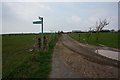
Public Footpath
The path follows this farm track as far as the woodland just ahead, there it joins up with the Erme-Plym Trail.
Image: © jeff collins
Taken: 26 Mar 2014
0.15 miles
5
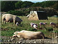
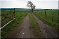
Barn Farm
To the south of Jennyscombe Wood and traversed by footpaths, the fields of Barn Farm are the home to a piggery.
Image: © Gwyn Jones
Taken: 6 Sep 2005
0.19 miles