IMAGES TAKEN NEAR TO
Plymstock, PLYMOUTH, PL9 9NH
Introduction
This page details the photographs taken nearby to PL9 9NH by members of the Geograph project.
The Geograph project started in 2005 with the aim of publishing, organising and preserving representative images for every square kilometre of Great Britain, Ireland and the Isle of Man.

There are currently over 7.5m images from over14,400 individuals and you can help contribute to the project by visiting https://www.geograph.org.uk
Image Map
Images are licensed for reuse under creativecommons.org/licenses/by-sa/2.0
Notes
- Clicking on the map will re-center to the selected point.
- The higher the marker number, the further away the image location is from the centre of the postcode.
Image Listing (4 Images Found)
Images are licensed for reuse under creativecommons.org/licenses/by-sa/2.0
Image
Details
Distance
1
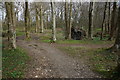
Entering Radford Woods
Close to the Erme-Plym Trail.
Image: © jeff collins
Taken: 26 Mar 2014
0.13 miles
2
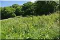
Radford Woods
These woods once provided a landscaped backdrop to Radford House, an Elizabethan mansion that was demolished in the 1930s. The land, covering 38 hectares, eventually passed to Plymouth City Council for use as a recreational area.
Image: © Stephen McKay
Taken: 11 Jun 2017
0.18 miles
3
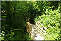
Radford Woods
A boardwalk is provided across the stream and through to White Lady Road. These woods originally belonged to the now-demolished Radford House and passed to Plymouth City Council for recreational use in the 1950s.
Image: © Stephen McKay
Taken: 11 Jun 2017
0.19 miles
4

Par of the Erme-Plym Trail
The path here is narrow and squashed in between the hedge and fence. Heading towards Staddiscombe.
Image: © jeff collins
Taken: 26 Mar 2014
0.19 miles