IMAGES TAKEN NEAR TO
Underlane, PLYMOUTH, PL9 9LD
Introduction
This page details the photographs taken nearby to Underlane, PL9 9LD by members of the Geograph project.
The Geograph project started in 2005 with the aim of publishing, organising and preserving representative images for every square kilometre of Great Britain, Ireland and the Isle of Man.

There are currently over 7.5m images from over14,400 individuals and you can help contribute to the project by visiting https://www.geograph.org.uk
Image Map
Images are licensed for reuse under creativecommons.org/licenses/by-sa/2.0
Notes
- Clicking on the map will re-center to the selected point.
- The higher the marker number, the further away the image location is from the centre of the postcode.
Image Listing (21 Images Found)
Images are licensed for reuse under creativecommons.org/licenses/by-sa/2.0
Image
Details
Distance
1
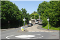
Hooe Road, Plymstock
Mini-roundabout at the junction of Hooe Road and White Lady Road.
Image: © Stephen McKay
Taken: 11 Jun 2017
0.07 miles
2
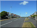
Two bus stops
One either side of the road in Mountbatten Way.
Image: © Anthony Vosper
Taken: 29 Jun 2023
0.08 miles
3
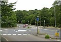
Roundabout on Hooe Road
The principal access to Hooe, Turnchapel and Mount Batten
Image: © Alan Murray-Rust
Taken: 28 Jun 2023
0.09 miles
4
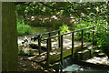
Footbridge - Radford Lake
Two dogs play in the stream feeding Radford Lake.
Image: © Stephen McKay
Taken: 11 Jun 2017
0.09 miles
5

Mayers Way
Mayers Way and the Beckly centre
Image: © Shaun Ferguson
Taken: 14 Aug 2010
0.10 miles
6
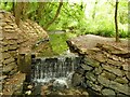
Weir at the top of Radford Lake
The inflow rate in summer is quite modest.
Image: © Stephen Craven
Taken: 28 Jun 2023
0.13 miles
7
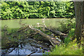
Radford Lake
Fallen trees lie in the water on the south side of the lake.
Image: © Stephen McKay
Taken: 11 Jun 2017
0.15 miles
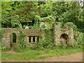
8
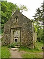
Ruins of Armoury Cottage (1)
Along with the nearby St Keverne's Cottage (or St Kevin's, depending on sources consulted) and its boathouse, this ruin is listed grade II (list entry 1386348). It is only 19th century but looks older as it was deliberately built in an older style, possibly with some original architectural features. See also Image
Image: © Stephen Craven
Taken: 28 Jun 2023
0.16 miles
9
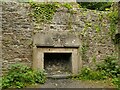
Ruins of Armoury Cottage (2)
Along with the nearby St Keverne's Cottage (or St Kevin's, depending on sources consulted) and its boathouse, this ruin is listed grade II (list entry 1386348). It is only 19th century but looks older as it was deliberately built in an older style, possibly with some original architectural features. See also Image
Image: © Stephen Craven
Taken: 28 Jun 2023
0.16 miles
10
Ruins of Armoury Cottage (3)
Along with the nearby St Keverne's Cottage (or St Kevin's, depending on sources consulted) and its boathouse, this ruin is listed grade II (list entry 1386348). It is only 19th century but looks older as it was deliberately built in an older style, possibly with some original architectural features. See also Image
Image: © Stephen Craven
Taken: 28 Jun 2023
0.16 miles