IMAGES TAKEN NEAR TO
Outcrop Road, PLYMOUTH, PL9 9FR
Introduction
This page details the photographs taken nearby to Outcrop Road, PL9 9FR by members of the Geograph project.
The Geograph project started in 2005 with the aim of publishing, organising and preserving representative images for every square kilometre of Great Britain, Ireland and the Isle of Man.

There are currently over 7.5m images from over14,400 individuals and you can help contribute to the project by visiting https://www.geograph.org.uk
Image Map
Images are licensed for reuse under creativecommons.org/licenses/by-sa/2.0
Notes
- Clicking on the map will re-center to the selected point.
- The higher the marker number, the further away the image location is from the centre of the postcode.
Image Listing (202 Images Found)
Images are licensed for reuse under creativecommons.org/licenses/by-sa/2.0
Image
Details
Distance


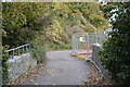
3
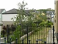
Walkway to Causeway View
This was the site of Turnchapel station. The area, which was largely a quarry, was only developed for housing in the early years of the 21st century.
Image: © Alan Murray-Rust
Taken: 27 Jun 2023
0.04 miles
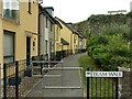
4
Tram Walk, off Undercliff Road, Turnchapel
Named after a single-track mineral railway that once served the extensive Hooelake Quarry within which this housing estate was subsequently built (the edge of the quarry can be seen in the distance). It crossed this path diagonally in the foreground of the photo.
Image: © Stephen Craven
Taken: 28 Jun 2023
0.05 miles
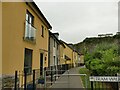
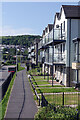
5

Tram Walk, Turnchapel
These houses were built in what was Turnchapel Quarry as part of the 'Reflections' estate. This is the view from Undercliff Road.
Image: © Stephen McKay
Taken: 30 May 2021
0.05 miles
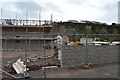
6
Tram Walk, Turnchapel
The walk takes its name from the tramway which connected the quarry to the wharves. The housing is early 21st century development within the area of the quarry.
Image: © Alan Murray-Rust
Taken: 27 Jun 2023
0.06 miles
9
Barton Road, Hooe
The three storey houses here overlooking Hooe Lake were built around 2015 as part of the Reflections estate.
Image: © Stephen McKay
Taken: 30 May 2021
0.07 miles
10
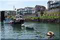
Hooe Lake Entrance
The narrow entrance channel to Hooe Lake is used for mooring boats on two parallel trotlines; two of the vessels can be seen here. Behind them is one of the piers that once carried the Turnchapel branch line railway. The houses are part of the Reflections estate.
Image: © Stephen McKay
Taken: 31 May 2021
0.07 miles