IMAGES TAKEN NEAR TO
Holmwood Avenue, PLYMOUTH, PL9 9EX
Introduction
This page details the photographs taken nearby to Holmwood Avenue, PL9 9EX by members of the Geograph project.
The Geograph project started in 2005 with the aim of publishing, organising and preserving representative images for every square kilometre of Great Britain, Ireland and the Isle of Man.

There are currently over 7.5m images from over14,400 individuals and you can help contribute to the project by visiting https://www.geograph.org.uk
Image Map
Images are licensed for reuse under creativecommons.org/licenses/by-sa/2.0
Notes
- Clicking on the map will re-center to the selected point.
- The higher the marker number, the further away the image location is from the centre of the postcode.
Image Listing (4 Images Found)
Images are licensed for reuse under creativecommons.org/licenses/by-sa/2.0
Image
Details
Distance
1
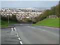
Goosewell Road
Looking across Plymstock.
Image: © Rod Allday
Taken: 24 Oct 2009
0.10 miles
2
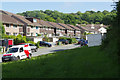
Holmwood Avenue, Plymstock
Semi-detached houses in the Goosewell area of Plymstock.
Image: © Stephen McKay
Taken: 11 Jun 2017
0.16 miles
3
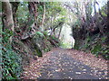
Pedestrianised lane behind Goswela Gardens
Was originally a vehicular route but now barred by bollards.
Image: © Rod Allday
Taken: 24 Oct 2009
0.22 miles
4
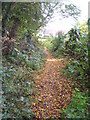
Footpath on the edge of Jew's Wood Plymstock
Image: © Rod Allday
Taken: 24 Oct 2009
0.22 miles