IMAGES TAKEN NEAR TO
Mayflower Close, PLYMOUTH, PL9 8SJ
Introduction
This page details the photographs taken nearby to Mayflower Close, PL9 8SJ by members of the Geograph project.
The Geograph project started in 2005 with the aim of publishing, organising and preserving representative images for every square kilometre of Great Britain, Ireland and the Isle of Man.

There are currently over 7.5m images from over14,400 individuals and you can help contribute to the project by visiting https://www.geograph.org.uk
Image Map
Images are licensed for reuse under creativecommons.org/licenses/by-sa/2.0
Notes
- Clicking on the map will re-center to the selected point.
- The higher the marker number, the further away the image location is from the centre of the postcode.
Image Listing (77 Images Found)
Images are licensed for reuse under creativecommons.org/licenses/by-sa/2.0
Image
Details
Distance
2
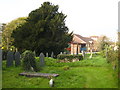
A fine yew tree in St Mary's churchyard
Taxus baccata, the yew, is frequently found in churchyards. It is thought that because almost every part of the tree is very poisonous they were so planted to discourage farmers from allowing their stock to invade the sacred area.
Image: © Rod Allday
Taken: 24 Oct 2009
0.07 miles
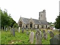
3
Church of St Mary and All Saints, Plymstock
The east end of the church, showing how the land was cut into to allow the church to be built on the level.
Image: © Alan Murray-Rust
Taken: 28 Jun 2023
0.07 miles
4
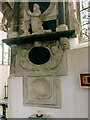
Church of St Mary and All Saints, Plymstock
Monument to John Harrys, d.1677, lower portion, see also https://www.geograph.org.uk/photo/7531057.
Image: © Alan Murray-Rust
Taken: 28 Jun 2023
0.08 miles
5
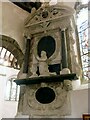
Church of St Mary and All Saints, Plymstock
Monument to John Harrys, d.1677, upper portion, see also https://www.geograph.org.uk/photo/7531058.
Image: © Alan Murray-Rust
Taken: 28 Jun 2023
0.08 miles
6
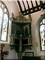
Church of St Mary and All Saints, Plymstock
Harrys (Harris) family monument in the south aisle. There is no discernable inscription, but the style is early 17th century.
Image: © Alan Murray-Rust
Taken: 28 Jun 2023
0.08 miles
7
Church of St Mary and All Saints, Plymstock
View from the north east. The projection for the staircase to the rood can be seen between the two nearer windows of the aisle.
Image: © Alan Murray-Rust
Taken: 28 Jun 2023
0.08 miles
8
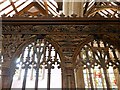
Church of St Mary and All Saints, Plymstock
Detail of the forward face of the screen, showing the in-filled vault spandrels. Traces of original paint can be seen on the capital of the main support. The screen would probably have looked similar to this one https://www.geograph.org.uk/photo/991703
Image: © Alan Murray-Rust
Taken: 28 Jun 2023
0.08 miles
9
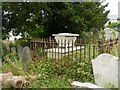
Church of St Mary and All Saints, Plymstock
Treeby family tomb in the churchyard, dated 1821, Listed Grade II.
Image: © Alan Murray-Rust
Taken: 28 Jun 2023
0.08 miles
10
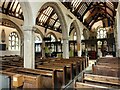
Church of St Mary and All Saints, Plymstock
General interior view from the south aisle. The arcade is mid 14th century.
Image: © Alan Murray-Rust
Taken: 28 Jun 2023
0.08 miles