IMAGES TAKEN NEAR TO
Standarhay Close, PLYMOUTH, PL9 8PL
Introduction
This page details the photographs taken nearby to Standarhay Close, PL9 8PL by members of the Geograph project.
The Geograph project started in 2005 with the aim of publishing, organising and preserving representative images for every square kilometre of Great Britain, Ireland and the Isle of Man.

There are currently over 7.5m images from over14,400 individuals and you can help contribute to the project by visiting https://www.geograph.org.uk
Image Map
Images are licensed for reuse under creativecommons.org/licenses/by-sa/2.0
Notes
- Clicking on the map will re-center to the selected point.
- The higher the marker number, the further away the image location is from the centre of the postcode.
Image Listing (54 Images Found)
Images are licensed for reuse under creativecommons.org/licenses/by-sa/2.0
Image
Details
Distance
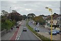
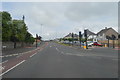
2
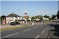
Main Road Through Elburton
There is all the clutter here which you would expect to see on a busy commuter route.
Image: © Tony Atkin
Taken: 24 May 2009
0.09 miles
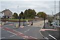
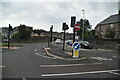
5
Plymouth : Elburton - Elburton Road Roundabout
The first of two roundabouts on this road in this gridsquare. The road joining to the left is Haye Road.
Image: © Lewis Clarke
Taken: 16 Jun 2010
0.09 miles
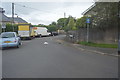
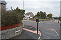
7
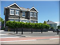
Plymouth : Elburton - Pavement and House
A house - or what could be a flat - near the roundabout on Elburton Road A379.
Image: © Lewis Clarke
Taken: 16 Jun 2010
0.10 miles