IMAGES TAKEN NEAR TO
Aquarius Drive, PLYMOUTH, PL9 8FH
Introduction
This page details the photographs taken nearby to Aquarius Drive, PL9 8FH by members of the Geograph project.
The Geograph project started in 2005 with the aim of publishing, organising and preserving representative images for every square kilometre of Great Britain, Ireland and the Isle of Man.

There are currently over 7.5m images from over14,400 individuals and you can help contribute to the project by visiting https://www.geograph.org.uk
Image Map
Images are licensed for reuse under creativecommons.org/licenses/by-sa/2.0
Notes
- Clicking on the map will re-center to the selected point.
- The higher the marker number, the further away the image location is from the centre of the postcode.
Image Listing (17 Images Found)
Images are licensed for reuse under creativecommons.org/licenses/by-sa/2.0
Image
Details
Distance
1
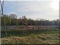
Sherford Play Park
Sherford's new park, opened May 2021.
Image: © Charli
Taken: 20 Apr 2021
0.04 miles
2
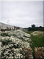
A sea of daisies
Taken from the new Sherford play park.
Image: © Charli
Taken: 19 Jun 2021
0.05 miles
3
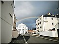
Rainbow over Hercules Road
Rainbow over Hercules Road, taken from Pegasus Place.
Image: © Charli
Taken: 30 Oct 2021
0.10 miles
4

Sherford
Looking in the opposite direction to; Image]
Image: © jeff collins
Taken: 18 Jul 2020
0.15 miles
5
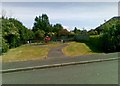
Play area off Candish Drive, Plymouth
Image: © Alex McGregor
Taken: 14 Jun 2011
0.15 miles
6
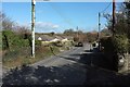
Sherford Road, Elburton
Just about to leave suburbia and enter the countryside. A busy lane today, possibly because of roadwork diversions.
Image: © Derek Harper
Taken: 5 Mar 2016
0.15 miles
7
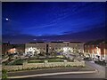
Boundary Park
Sunset over Boundary Park on Dorado Street, Sherford
Image: © Charli
Taken: 15 Jun 2021
0.16 miles
8
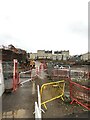
Housing development
Part of the very large housing development at Sherford.
Image: © jeff collins
Taken: 29 Oct 2020
0.16 miles
9

New housing, Sherford
The old minor road as seen on the map has long since disappeared. To be replaced with this modern road and town style housing, of which some is occupied and some for sale.
Image: © jeff collins
Taken: 18 Jul 2020
0.17 miles
10
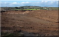
Sherford New Town
Well, not quite yet, perhaps. This view is from Sherford Road, looking towards Priors Park Nursery with Furze Park on the right, and covers only a fragment of the area to be transformed. "Sherford will occupy over 1,200 acres of farmland between the A38 and A379. Set in one of the country’s most picturesque locations, Sherford will both respect and enhance the surrounding landscape - making it one of the most desirable places to live and work for 12,000 residents" http://sherford.org/ .
Image: © Derek Harper
Taken: 5 Mar 2016
0.17 miles