IMAGES TAKEN NEAR TO
Colesdown Hill, PLYMOUTH, PL9 8AQ
Introduction
This page details the photographs taken nearby to Colesdown Hill, PL9 8AQ by members of the Geograph project.
The Geograph project started in 2005 with the aim of publishing, organising and preserving representative images for every square kilometre of Great Britain, Ireland and the Isle of Man.

There are currently over 7.5m images from over14,400 individuals and you can help contribute to the project by visiting https://www.geograph.org.uk
Image Map
Images are licensed for reuse under creativecommons.org/licenses/by-sa/2.0
Notes
- Clicking on the map will re-center to the selected point.
- The higher the marker number, the further away the image location is from the centre of the postcode.
Image Listing (7 Images Found)
Images are licensed for reuse under creativecommons.org/licenses/by-sa/2.0
Image
Details
Distance
1
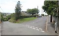
First Avenue, Billacombe
The southernmost of three short cul-de-sacs (you can guess the names of the other two) seen from the junction with Colesdown Hill. Both roads soon pass into Image
Image: © Derek Harper
Taken: 1 Jul 2011
0.10 miles
2
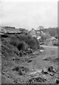
Site of Billacombe Station
View eastwards, towards Yealmpton. This is a final view of the track-bed before being buried under a by-pass. Passenger trains to Yealmpton ran from Plymouth (Millbay) GWR until the line was closed on 7/7/30. Then during World War II, when Plymouth was so badly blitzed and people moved out to the surrounding country villages, the Yealmpton branch (and Billacombe station) was reopened on 3/11/41, but with trains running from Plymouth (Friary) SR. The passenger service lasted only until 6/10/47, goods until 29/2/60.
Image: © Ben Brooksbank
Taken: 18 Apr 1964
0.14 miles
3
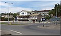
Billacombe Tavern
A suburban pub by a roundabout on the A379, where Billacombe Road becomes Elburton Road.
Image: © Derek Harper
Taken: 1 Jul 2011
0.20 miles
4
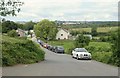
Road into Wixenford Farm
And into the industrial estate adjoining it, seen from the junction with Colesdown Hill.
Image: © Derek Harper
Taken: 1 Jul 2011
0.23 miles
5
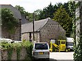
Barn, Wixenford Farm
The east end of this listed C18 barn, with its half-hipped roof, has 6 tiers of pigeon holes http://www.britishlistedbuildings.co.uk/en-473275-outbuilding-adjoining-north-east-of-wixe .
Image: © Derek Harper
Taken: 1 Jul 2011
0.24 miles
6
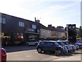
Car dealer and suburban houses, Plymstock
On the westbound carriageway of Billacombe Road (A379)
Image: © David Smith
Taken: 28 Sep 2015
0.24 miles
7
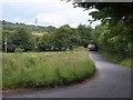
Colesdown Hill
From the same spot as Image, looking along the road as it passes a gas relay station screened by trees.
Image: © Derek Harper
Taken: 1 Jul 2011
0.24 miles