IMAGES TAKEN NEAR TO
Marine Road, PLYMOUTH, PL9 7NL
Introduction
This page details the photographs taken nearby to Marine Road, PL9 7NL by members of the Geograph project.
The Geograph project started in 2005 with the aim of publishing, organising and preserving representative images for every square kilometre of Great Britain, Ireland and the Isle of Man.

There are currently over 7.5m images from over14,400 individuals and you can help contribute to the project by visiting https://www.geograph.org.uk
Image Map
Images are licensed for reuse under creativecommons.org/licenses/by-sa/2.0
Notes
- Clicking on the map will re-center to the selected point.
- The higher the marker number, the further away the image location is from the centre of the postcode.
Image Listing (78 Images Found)
Images are licensed for reuse under creativecommons.org/licenses/by-sa/2.0
Image
Details
Distance
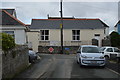
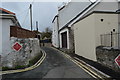
4
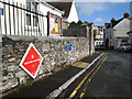
Park Lane Oreston
Part of the route of the South West Coast Path. Where the path passes through the industrial and residential areas around Plymouth these striking direction signs have been used.
Image: © Rod Allday
Taken: 24 Oct 2009
0.01 miles
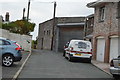
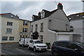
5
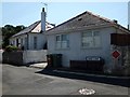
Park Lane, Oreston
Not quite the same as its more famous counterpart! The South West Coast Path runs along this road, and a plaque notes that the name "Park Lane" was recorded on maps 200 years ago - but nobody is sure to which "Park" it refers.
Image: © David Smith
Taken: 22 Aug 2013
0.02 miles