IMAGES TAKEN NEAR TO
Breakwater Road, PLYMOUTH, PL9 7HW
Introduction
This page details the photographs taken nearby to Breakwater Road, PL9 7HW by members of the Geograph project.
The Geograph project started in 2005 with the aim of publishing, organising and preserving representative images for every square kilometre of Great Britain, Ireland and the Isle of Man.

There are currently over 7.5m images from over14,400 individuals and you can help contribute to the project by visiting https://www.geograph.org.uk
Image Map
Images are licensed for reuse under creativecommons.org/licenses/by-sa/2.0
Notes
- Clicking on the map will re-center to the selected point.
- The higher the marker number, the further away the image location is from the centre of the postcode.
Image Listing (74 Images Found)
Images are licensed for reuse under creativecommons.org/licenses/by-sa/2.0
Image
Details
Distance
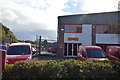
1
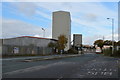
Royal Mail centre, Oreston
Royal Mail distribution centre in Oreston near Plymouth.
Image: © Philip Halling
Taken: 4 Jun 2011
0.05 miles
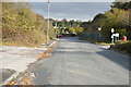
7
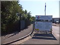
South West Coast Path at the end of Breakwater Road
A newly opened section of the coastal footpath runs beside the chain link fence
Image: © David Smith
Taken: 22 Aug 2013
0.13 miles