IMAGES TAKEN NEAR TO
Billacombe Road, PLYMOUTH, PL9 7HD
Introduction
This page details the photographs taken nearby to Billacombe Road, PL9 7HD by members of the Geograph project.
The Geograph project started in 2005 with the aim of publishing, organising and preserving representative images for every square kilometre of Great Britain, Ireland and the Isle of Man.

There are currently over 7.5m images from over14,400 individuals and you can help contribute to the project by visiting https://www.geograph.org.uk
Image Map
Images are licensed for reuse under creativecommons.org/licenses/by-sa/2.0
Notes
- Clicking on the map will re-center to the selected point.
- The higher the marker number, the further away the image location is from the centre of the postcode.
Image Listing (10 Images Found)
Images are licensed for reuse under creativecommons.org/licenses/by-sa/2.0
Image
Details
Distance
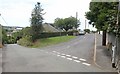
1
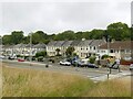
Spencer Terrace, Billacombe Road
Old OS maps show that the terrace was built in total isolation around 1900, with newer housing only following much later.
Image: © Alan Murray-Rust
Taken: 28 Jun 2023
0.01 miles
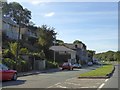
2
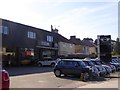
Car dealer and suburban houses, Plymstock
On the westbound carriageway of Billacombe Road (A379)
Image: © David Smith
Taken: 28 Sep 2015
0.09 miles
3
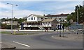
Billacombe Tavern
A suburban pub by a roundabout on the A379, where Billacombe Road becomes Elburton Road.
Image: © Derek Harper
Taken: 1 Jul 2011
0.12 miles
4
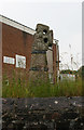
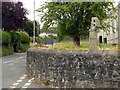
Old Wayside Cross by Stentaway Road, Plymstock, Plymouth
Stentaway Cross, old head and shaft, by the UC road, in parish of Plymouth (Plymouth District), Stentaway House (Telephone exchange), Stentaway Road, Plymstock, on a high bank at the entrance to the car park.
Scheduled Monument
List Entry Number: 1003834 https://historicengland.org.uk/listing/the-list/list-entry/1003834
Surveyed
Milestone Society National ID: DVPL_PLY05
Image: © Alan Rosevear
Taken: 27 Jun 2011
0.16 miles
5
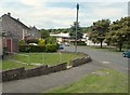
Celtic Cross, Stentaway Road, Plymstock
Recreating this 'First' for the square https://www.geograph.org.uk/photo/58419.
The cross is a designated Scheduled Monument, the listing including the following information:
“The pre-Conquest standing cross and early Christian memorial stone . . . is unique in Devon; it is of a type of cross more commonly found in Cornwall. It has an inscription indicative of an early Christian memorial stone, although these are normally found on plain stones, not those shaped into crosses. . . . The cross was moved to its current location in 1946; it had been in a field used as a rubbing post for livestock. . . . It is thought to date to between the 9th and 11th centuries.”
Image: © Alan Murray-Rust
Taken: 28 Jun 2023
0.16 miles
6
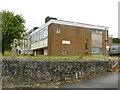
Telephone exchange, Stentaway Road, Plymstock
Clearly built (1959) to serve the rapidly developing suburbs in the Plymstock area.
Image: © Alan Murray-Rust
Taken: 28 Jun 2023
0.16 miles
7
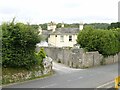
Stentaway Drive
Seen from the junction with Stentaway Close. That big white building on the other side of Stentaway Road is Fairway Furniture, which faces Image
Image: © Derek Harper
Taken: 1 Jul 2011
0.17 miles
8
Stentaway House, Stentaway Road, Plymstock
Early 19th century large detached house in Regency style. Listed Grade II.
Image: © Alan Murray-Rust
Taken: 28 Jun 2023
0.20 miles
9
First Avenue, Billacombe
The southernmost of three short cul-de-sacs (you can guess the names of the other two) seen from the junction with Colesdown Hill. Both roads soon pass into Image
Image: © Derek Harper
Taken: 1 Jul 2011
0.20 miles
10
Service road by Billacombe Road, Plymstock
Image: © David Smith
Taken: 28 Sep 2015
0.22 miles