IMAGES TAKEN NEAR TO
Cotswold Avenue, PL9 7GR
Introduction
This page details the photographs taken nearby to Cotswold Avenue, PL9 7GR by members of the Geograph project.
The Geograph project started in 2005 with the aim of publishing, organising and preserving representative images for every square kilometre of Great Britain, Ireland and the Isle of Man.

There are currently over 7.5m images from over14,400 individuals and you can help contribute to the project by visiting https://www.geograph.org.uk
Image Map
Images are licensed for reuse under creativecommons.org/licenses/by-sa/2.0
Notes
- Clicking on the map will re-center to the selected point.
- The higher the marker number, the further away the image location is from the centre of the postcode.
Image Listing (11 Images Found)
Images are licensed for reuse under creativecommons.org/licenses/by-sa/2.0
Image
Details
Distance

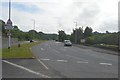
3

The A379 near Pomphlett
Recreating this 'First' for the square https://www.geograph.org.uk/photo/188359 .
There is now a new roundabout with access to the Morley Park/Saltram Meadows housing development.
Image: © Alan Murray-Rust
Taken: 28 Jun 2023
0.12 miles
4
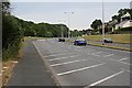
The A379 near Pomphlett
This busy commuter route into Plymouth was originally built with two lanes in each direction. If you look at the road markings on the near carriageway, you will see it has been reduced to a single lane and a cycle lane. This was not done out of any particular love of cyclists, but because it was found that the traffic actually moved better with a single lane.
Image: © Tony Atkin
Taken: 18 Jun 2006
0.13 miles
5
Morley Meadow School access
Part of the large Saltram Meadows housing development in former quarries.
Image: © Alan Murray-Rust
Taken: 28 Jun 2023
0.15 miles
6

Housing in a quarry
This is the extensive Saltram Meadows scheme which includes several hundred dwellings overall.
Image: © Alan Murray-Rust
Taken: 28 Jun 2023
0.16 miles
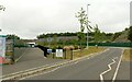
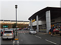
8

New multi-user path along the old railway
Not formally open at this point. The path follows the former Great Western Railway branch to Yealmpton, which closed to passengers an 1947 and freight in 1960.
Image: © Alan Murray-Rust
Taken: 28 Jun 2023
0.21 miles
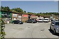
9
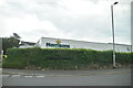
Morrisons, Pomphlett
Morrisons geared up for a Christmas Eve food shopping crowd.
Image: © Stephen McKay
Taken: 24 Dec 2016
0.22 miles