IMAGES TAKEN NEAR TO
Ryeland Close, PLYMOUTH, PL9 0HZ
Introduction
This page details the photographs taken nearby to Ryeland Close, PL9 0HZ by members of the Geograph project.
The Geograph project started in 2005 with the aim of publishing, organising and preserving representative images for every square kilometre of Great Britain, Ireland and the Isle of Man.

There are currently over 7.5m images from over14,400 individuals and you can help contribute to the project by visiting https://www.geograph.org.uk
Image Map
Images are licensed for reuse under creativecommons.org/licenses/by-sa/2.0
Notes
- Clicking on the map will re-center to the selected point.
- The higher the marker number, the further away the image location is from the centre of the postcode.
Image Listing (30 Images Found)
Images are licensed for reuse under creativecommons.org/licenses/by-sa/2.0
Image
Details
Distance
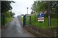
6
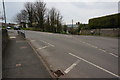
Fork in the road
Left to Wembury Beach and church and straight on to West Wembury local shops etc.
Image: © jeff collins
Taken: 26 Mar 2014
0.12 miles
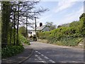
7
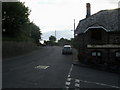
Knighton Road
Knighton Road passing Traine Road and The Odd Wheel
Image: © Shaun Ferguson
Taken: 7 Aug 2010
0.13 miles