IMAGES TAKEN NEAR TO
Traine Road, PLYMOUTH, PL9 0EN
Introduction
This page details the photographs taken nearby to Traine Road, PL9 0EN by members of the Geograph project.
The Geograph project started in 2005 with the aim of publishing, organising and preserving representative images for every square kilometre of Great Britain, Ireland and the Isle of Man.

There are currently over 7.5m images from over14,400 individuals and you can help contribute to the project by visiting https://www.geograph.org.uk
Image Map
Images are licensed for reuse under creativecommons.org/licenses/by-sa/2.0
Notes
- Clicking on the map will re-center to the selected point.
- The higher the marker number, the further away the image location is from the centre of the postcode.
Image Listing (10 Images Found)
Images are licensed for reuse under creativecommons.org/licenses/by-sa/2.0
Image
Details
Distance
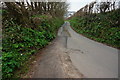
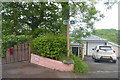
1
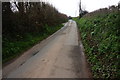
Traine Road
Heading towards Knighton. The Erme-Plym Trail follows the road.
Image: © jeff collins
Taken: 26 Mar 2014
0.08 miles
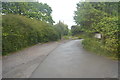
2
The Road at Hollacombe Hill
This is the road to Knighton and Wembury. There are houses built along the top of the steep valleyside on the other side of the road.
Image: © Tony Atkin
Taken: 12 Jul 2009
0.16 miles
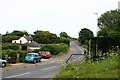
5
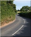
Wembury Road
The busy winding road from Plymstock to Knighton and Wembury.
Image: © Derek Harper
Taken: 1 Jul 2011
0.18 miles
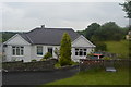
6
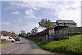
Bus shelter and houses, Hollacombe
Wembury Road is a busy road through Hollacombe to Wembury and Knighton, served by a regular bus service from Plymouth
Image: © David Smith
Taken: 16 Apr 2015
0.19 miles
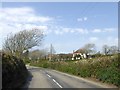
7
Traine Road just passed Traine Farm
In the distance the outskirts of Knighton can be seen.
Image: © jeff collins
Taken: 26 Mar 2014
0.20 miles
10
Windswept tree, Wembury Road
The road passing Trescan (which sounds as if it should be a Cornish name)
Image: © David Smith
Taken: 16 Apr 2015
0.24 miles