IMAGES TAKEN NEAR TO
Marine Drive West, PLYMOUTH, PL9 0BX
Introduction
This page details the photographs taken nearby to Marine Drive West, PL9 0BX by members of the Geograph project.
The Geograph project started in 2005 with the aim of publishing, organising and preserving representative images for every square kilometre of Great Britain, Ireland and the Isle of Man.

There are currently over 7.5m images from over14,400 individuals and you can help contribute to the project by visiting https://www.geograph.org.uk
Image Map
Images are licensed for reuse under creativecommons.org/licenses/by-sa/2.0
Notes
- Clicking on the map will re-center to the selected point.
- The higher the marker number, the further away the image location is from the centre of the postcode.
Image Listing (58 Images Found)
Images are licensed for reuse under creativecommons.org/licenses/by-sa/2.0
Image
Details
Distance

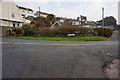
2
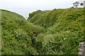
The Hey Brook
Just before it meets the sea at Heybrook Bay.
Image: © jeff collins
Taken: 26 Mar 2014
0.03 miles
3
Heybrook Bay
From the start of Beach Road looking across Heybrook Drive.
Image: © jeff collins
Taken: 26 Mar 2014
0.04 miles
4
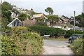
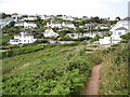
Wembury: by Heybrook Drive
Heybrook Bay village
Image: © Martin Bodman
Taken: 12 Sep 2013
0.04 miles
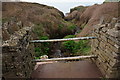
5

Heybrook Bay : Beach Road
Beach Road heading along the coastline and taking the coastal path with it.
Image: © Lewis Clarke
Taken: 25 Jul 2012
0.05 miles
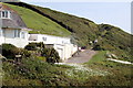
6
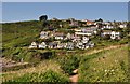
South Hams : Heybrook Bay
A coastal residential village overlooking the bay and along the South West Coastal Path.
Image: © Lewis Clarke
Taken: 25 Jul 2012
0.05 miles