IMAGES TAKEN NEAR TO
Chittleburn Close, PLYMOUTH, PL8 2FL
Introduction
This page details the photographs taken nearby to Chittleburn Close, PL8 2FL by members of the Geograph project.
The Geograph project started in 2005 with the aim of publishing, organising and preserving representative images for every square kilometre of Great Britain, Ireland and the Isle of Man.

There are currently over 7.5m images from over14,400 individuals and you can help contribute to the project by visiting https://www.geograph.org.uk
Image Map
Images are licensed for reuse under creativecommons.org/licenses/by-sa/2.0
Notes
- Clicking on the map will re-center to the selected point.
- The higher the marker number, the further away the image location is from the centre of the postcode.
Image Listing (56 Images Found)
Images are licensed for reuse under creativecommons.org/licenses/by-sa/2.0
Image
Details
Distance
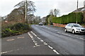
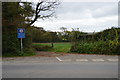
1
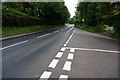
A379 approaching Brixton
After leaving Brixton the Erme-Plym Trail goes right at this junction.
Image: © jeff collins
Taken: 8 Jul 2015
0.03 miles
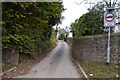
6
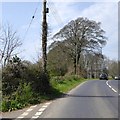
A379 west of Brixton
The minor road to the left leads to Cofflete Image
Image: © David Smith
Taken: 16 Apr 2015
0.04 miles