IMAGES TAKEN NEAR TO
Yealmpton, PLYMOUTH, PL8 2ET
Introduction
This page details the photographs taken nearby to PL8 2ET by members of the Geograph project.
The Geograph project started in 2005 with the aim of publishing, organising and preserving representative images for every square kilometre of Great Britain, Ireland and the Isle of Man.

There are currently over 7.5m images from over14,400 individuals and you can help contribute to the project by visiting https://www.geograph.org.uk
Image Map (Loading...)


Getting Data...Please wait
Leaflet Map data © OpenStreetMap
Images are licensed for reuse under creativecommons.org/licenses/by-sa/2.0
Notes
- Clicking on the map will re-center to the selected point.
- The higher the marker number, the further away the image location is from the centre of the postcode.
Image Listing (10 Images Found)
Images are licensed for reuse under creativecommons.org/licenses/by-sa/2.0
Image
Details
Distance
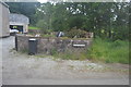
2
Bend in the A379 east of Dunstone
The house is in Image but the bend is (just) in the grid square
Image: © David Smith
Taken: 16 Apr 2015
0.07 miles
3
Across the Long Brook to Greenacres
Taken from almost the same spot as Image, but the Long Brook runs south for about 25 metres beside the Wilburton Lane before turning across the middle of this field. Greenacres stands beside the A379 and is across a gridline, as is Butland Wood, on the hill behind.
Image: © Derek Harper
Taken: 26 Nov 2006
0.15 miles
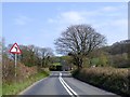
4
The lane to Wilburton
An almost straight lane dips down to cross the Long Brook, a tributary of the Yealm, which cuts across the southern half of this square. The lane then climbs to Wilburton, whose buildings are in the distance.
Image: © Derek Harper
Taken: 26 Nov 2006
0.19 miles
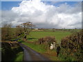
5
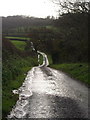
Wet lane below Wilburton
Rainwater and runoff from damp fields runs down the lane from Wilburton into the Long Brook valley.
Image: © Derek Harper
Taken: 26 Nov 2006
0.19 miles
6
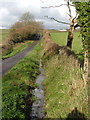
Ditch beside the lane to Wilburton
Image: © Derek Harper
Taken: 26 Nov 2006
0.19 miles
7
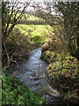
Long Brook
The Long Brook turns away from the lane between Butland and Wilburton to cross the field in Image
Image: © Derek Harper
Taken: 26 Nov 2006
0.21 miles
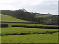
8
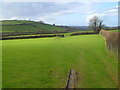
Field above Long Brook
Taken looking down the Long Brook valley from the lane shown in Image
Image: © Derek Harper
Taken: 26 Nov 2006
0.21 miles
9
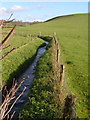
Long Brook
The stream has been neatly channelled across this particular field, although for most of its course it meanders around like streams should. View looking upstream from the dip shown in Image, past a protruding bit of hedge.
Image: © Derek Harper
Taken: 26 Nov 2006
0.23 miles
10
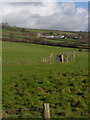
Long Brook and Burraton
A foreshortened view along a channelled section of Image Burraton lies in a different square (see Image).
Image: © Derek Harper
Taken: 26 Nov 2006
0.23 miles