IMAGES TAKEN NEAR TO
Tapps Lane, PLYMOUTH, PL8 2BZ
Introduction
This page details the photographs taken nearby to Tapps Lane, PL8 2BZ by members of the Geograph project.
The Geograph project started in 2005 with the aim of publishing, organising and preserving representative images for every square kilometre of Great Britain, Ireland and the Isle of Man.

There are currently over 7.5m images from over14,400 individuals and you can help contribute to the project by visiting https://www.geograph.org.uk
Image Map
Images are licensed for reuse under creativecommons.org/licenses/by-sa/2.0
Notes
- Clicking on the map will re-center to the selected point.
- The higher the marker number, the further away the image location is from the centre of the postcode.
Image Listing (36 Images Found)
Images are licensed for reuse under creativecommons.org/licenses/by-sa/2.0
Image
Details
Distance
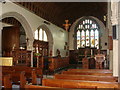
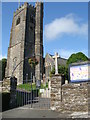
1
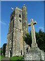
St. Mary's Church, Brixton
The village church and the memorial to the two world wars.
Image: © Gwyn Jones
Taken: 15 Oct 2005
0.07 miles
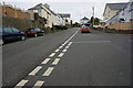
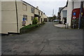
3
Brixton: houses in Red Lion Hill
Seen from the end of Woodland Drive
Image: © Martin Bodman
Taken: 12 Sep 2007
0.13 miles
5
St. Mary's church Brixton - interior
Image: © Ruth Sharville
Taken: 23 Jul 2009
0.15 miles
7
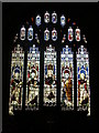
St. Mary's church Brixton - East window
Image: © Ruth Sharville
Taken: 23 Jul 2009
0.15 miles
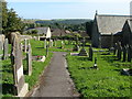
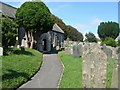
10
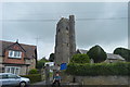
Church of St Mary
Grade I listed. https://britishlistedbuildings.co.uk/101325213-church-of-st-mary-brixton
Image: © N Chadwick
Taken: 1 Jun 2018
0.15 miles