IMAGES TAKEN NEAR TO
Church Hill, PLYMOUTH, PL8 1LN
Introduction
This page details the photographs taken nearby to Church Hill, PL8 1LN by members of the Geograph project.
The Geograph project started in 2005 with the aim of publishing, organising and preserving representative images for every square kilometre of Great Britain, Ireland and the Isle of Man.

There are currently over 7.5m images from over14,400 individuals and you can help contribute to the project by visiting https://www.geograph.org.uk
Image Map
Images are licensed for reuse under creativecommons.org/licenses/by-sa/2.0
Notes
- Clicking on the map will re-center to the selected point.
- The higher the marker number, the further away the image location is from the centre of the postcode.
Image Listing (45 Images Found)
Images are licensed for reuse under creativecommons.org/licenses/by-sa/2.0
Image
Details
Distance
4
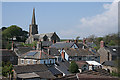
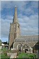
Holbeton: towards the church
All Saints church seen from the car park of the Dartmoor Union inn. Tower and spire are thought to date from the early fourteenth century
Image: © Martin Bodman
Taken: 23 Apr 2011
0.01 miles
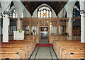
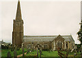
7
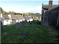
Holbeton churchyard, with houses on Church Hill
Image: © David Gearing
Taken: 1 Nov 2011
0.01 miles
8
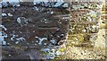
Ordnance Survey Cut Mark
This OS cut mark can be found on the west face of All Saints Church. It marks a point 56.946m above mean sea level.
Image: © Adrian Dust
Taken: 26 Mar 2019
0.01 miles
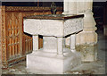
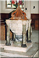
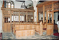
9
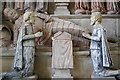
All Saints church, Holbeton - Hele family monument (detail 1)
Image: © Mike Searle
Taken: 25 Jun 2013
0.02 miles