IMAGES TAKEN NEAR TO
Plympton, PLYMOUTH, PL7 5AE
Introduction
This page details the photographs taken nearby to PL7 5AE by members of the Geograph project.
The Geograph project started in 2005 with the aim of publishing, organising and preserving representative images for every square kilometre of Great Britain, Ireland and the Isle of Man.

There are currently over 7.5m images from over14,400 individuals and you can help contribute to the project by visiting https://www.geograph.org.uk
Image Map (Loading...)


Getting Data...Please wait
Leaflet Map data © OpenStreetMap
Images are licensed for reuse under creativecommons.org/licenses/by-sa/2.0
Notes
- Clicking on the map will re-center to the selected point.
- The higher the marker number, the further away the image location is from the centre of the postcode.
Image Listing (16 Images Found)
Images are licensed for reuse under creativecommons.org/licenses/by-sa/2.0
Image
Details
Distance
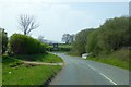
1
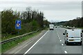
A38 Flyover, Brixton - Plympton Road
To the south of Plympton St Maurice, the A38 follows the line of the ridge, here crossing the minor road from Brixton to Plymton, before the road descends down into St Maurice.
Image: © Gwyn Jones
Taken: 15 Oct 2005
0.08 miles
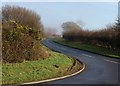
2
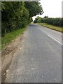
Minor road
Heading towards Brixton from Plympton St Maurice.
Image: © jeff collins
Taken: 18 Jul 2020
0.12 miles
3
Minor road to Plympton St Maurice
Close to Sherford.
Image: © jeff collins
Taken: 18 Jul 2020
0.16 miles
4

Flanders Poppies
Papaver rhoeas by the side of the new Sherford road.
Image: © jeff collins
Taken: 18 Jul 2020
0.17 miles
5
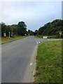
Junction with Plympton Hill
The minor road in the foreground links Deep Lane (east side of Plympton) with Plympton Hill (west or centre of Plympton)
Image: © David Smith
Taken: 16 Apr 2015
0.17 miles
6
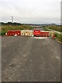
New road to Sherford
As yet not open. Close to Higher Sherford Farm,
Image: © jeff collins
Taken: 18 Jul 2020
0.17 miles
7
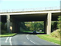
Road to Wiverton
The road, which was created when the adjacent A38 was built in 1970-1, leaves the road from Plympton to Brixton and runs along the south side of the dual carriageway. It replaces the eastern extension of Ridge Road, the no through road seen in the background of Image, which ran along the north side of the A38
Image: © Derek Harper
Taken: 10 Dec 2009
0.20 miles
8
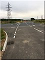
Road Junction on the new Sherford road
This is a reverse view of; Image] looking in the direction of The Deep Lane junction on the A38. The road on the left is the minor road to Brixton, which turns left here then almost immediately right to continue on towards Brixton.
Image: © jeff collins
Taken: 18 Jul 2020
0.20 miles
9

Unfinished new road
The new connecting road between Sherford and the Deep Lane junction on the A38. I would say not very long before it's open.
Image: © jeff collins
Taken: 18 Jul 2020
0.22 miles