IMAGES TAKEN NEAR TO
Deeble Close, PLYMOUTH, PL7 4BR
Introduction
This page details the photographs taken nearby to Deeble Close, PL7 4BR by members of the Geograph project.
The Geograph project started in 2005 with the aim of publishing, organising and preserving representative images for every square kilometre of Great Britain, Ireland and the Isle of Man.

There are currently over 7.5m images from over14,400 individuals and you can help contribute to the project by visiting https://www.geograph.org.uk
Image Map
Images are licensed for reuse under creativecommons.org/licenses/by-sa/2.0
Notes
- Clicking on the map will re-center to the selected point.
- The higher the marker number, the further away the image location is from the centre of the postcode.
Image Listing (7 Images Found)
Images are licensed for reuse under creativecommons.org/licenses/by-sa/2.0
Image
Details
Distance
1
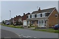
Clifton Avenue, Plympton
Modern housing estate
Image: © David Smith
Taken: 28 May 2016
0.09 miles
2
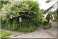
Colebrook Lane
An old lane which has survived the redevelopment of the surrounding area, and construction of new roads
Image: © David Smith
Taken: 28 May 2016
0.19 miles
3
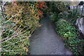
The Tory Brook
Looking upstream from the Newnham Road.
Image: © jeff collins
Taken: 19 Nov 2014
0.20 miles
4
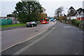
Newnham Road, Colebrook
Looking Southwest.
Image: © jeff collins
Taken: 19 Nov 2014
0.20 miles
5
Crossway, Plympton
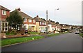
This road runs straight for 700 metres past semis in Colebrook on the north side of Plympton.
Image: © Derek Harper
Taken: 17 Jan 2015
0.21 miles
6
Tory Brook
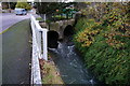
As it passes under Newnham Road.
Image: © jeff collins
Taken: 19 Nov 2014
0.21 miles
7
Peacock Meadow, Colebrook
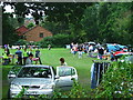
Regular car boot sales on the meadow aid funding of the community centre and annual events.
Image: © Gwyn Jones
Taken: 11 Sep 2005
0.21 miles