IMAGES TAKEN NEAR TO
Moulton Walk, PLYMOUTH, PL7 2XE
Introduction
This page details the photographs taken nearby to Moulton Walk, PL7 2XE by members of the Geograph project.
The Geograph project started in 2005 with the aim of publishing, organising and preserving representative images for every square kilometre of Great Britain, Ireland and the Isle of Man.

There are currently over 7.5m images from over14,400 individuals and you can help contribute to the project by visiting https://www.geograph.org.uk
Image Map (Loading...)


Getting Data...Please wait
Leaflet Map data © OpenStreetMap
Images are licensed for reuse under creativecommons.org/licenses/by-sa/2.0
Notes
- Clicking on the map will re-center to the selected point.
- The higher the marker number, the further away the image location is from the centre of the postcode.
Image Listing (24 Images Found)
Images are licensed for reuse under creativecommons.org/licenses/by-sa/2.0
Image
Details
Distance
8
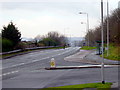
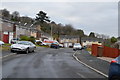
Glen Road
This is a main road through Chaddlewood. Normally this road is busy but on a Sunday morning it's quiet.
Image: © Tony Atkin
Taken: 8 Jan 2006
0.12 miles
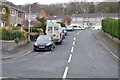
9
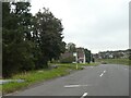
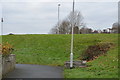
Bus stop on B3416, Glen Road
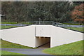
The access path from the left has come from an underpass linking housing estates on both sides of the busy road
Image: © David Smith
Taken: 22 Sep 2020
0.12 miles