IMAGES TAKEN NEAR TO
Hemerdon Heights, PLYMOUTH, PL7 2HA
Introduction
This page details the photographs taken nearby to Hemerdon Heights, PL7 2HA by members of the Geograph project.
The Geograph project started in 2005 with the aim of publishing, organising and preserving representative images for every square kilometre of Great Britain, Ireland and the Isle of Man.

There are currently over 7.5m images from over14,400 individuals and you can help contribute to the project by visiting https://www.geograph.org.uk
Image Map
Images are licensed for reuse under creativecommons.org/licenses/by-sa/2.0
Notes
- Clicking on the map will re-center to the selected point.
- The higher the marker number, the further away the image location is from the centre of the postcode.
Image Listing (7 Images Found)
Images are licensed for reuse under creativecommons.org/licenses/by-sa/2.0
Image
Details
Distance
3
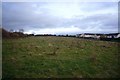
Field in Chaddlewood
This field is a remnant of Chaddlewood Farm, sandwiched between several housing estates that have been built piece-meal in recent years. At one time, the field was earmarked to be a playing field for a local school. It is now popular with dog walkers.
Image: © Nigel Mole
Taken: 25 Nov 2007
0.15 miles
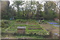
7
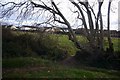
Old hedgebank, Chaddlewood
This hedgebank runs along the North edge of the field shown in Image The view through the hedgebank is towards houses at the top of Redwood Drive.
Image: © Nigel Mole
Taken: 25 Nov 2007
0.25 miles