IMAGES TAKEN NEAR TO
Downfield Way, PLYMOUTH, PL7 2DU
Introduction
This page details the photographs taken nearby to Downfield Way, PL7 2DU by members of the Geograph project.
The Geograph project started in 2005 with the aim of publishing, organising and preserving representative images for every square kilometre of Great Britain, Ireland and the Isle of Man.

There are currently over 7.5m images from over14,400 individuals and you can help contribute to the project by visiting https://www.geograph.org.uk
Image Map (Loading...)


Getting Data...Please wait
Leaflet Map data © OpenStreetMap
Images are licensed for reuse under creativecommons.org/licenses/by-sa/2.0
Notes
- Clicking on the map will re-center to the selected point.
- The higher the marker number, the further away the image location is from the centre of the postcode.
Image Listing (6 Images Found)
Images are licensed for reuse under creativecommons.org/licenses/by-sa/2.0
Image
Details
Distance
1

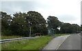
Horse chestnut flower, Plympton
By the path on the north side of Glen Road, the B3416.
Image: © Derek Harper
Taken: 5 Jul 2013
0.08 miles
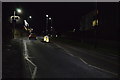
2
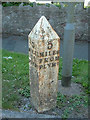
Old Milepost by the B3416, Manor Park Drive, Plymouth Parish
Cast iron post by the B3416 (was A38), in parish of PLYMOUTH (PLYMOUTH District), Plympton St Mary, Ridgeway, 30m West of Manor Park Close, close to road edge beside speed camera, on South side of road. Plymouth spear iron casting, erected by the Plymouth, Eastern turnpike trust in the 19th century.
Inscription reads:- : 5 / MILES / TO / PLYMo : : 5 / MILES / FROM / PLYMo :
Milestone Society National ID: DV_PLEX05.
Image: © Alan Rosevear
Taken: 15 Dec 2008
0.16 miles
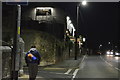
4
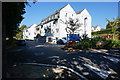
Thomas Pocklington Trust
Giving housing and support to people with sight loss. At the junction of George Lane and Ridgeway.
Image: © jeff collins
Taken: 10 Sep 2014
0.23 miles